Laguna de Guayatayoc
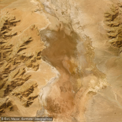
Laguna de Guayatayoc
- Boat Ramps
- 0
- Access Points
- 0
- Campsites
- 0
Laguna de Guayatayoc is a large saline lake situated in the southern part of the Cochinoca Department, Jujuy Province, in northwestern Argentina's high Andean Puna region. It sits at approximately 3,400 meters above sea level, with coordinates near 23°25′S 65°51′W. At peak water levels, the lake covers up to 240 square kilometers with a maximum depth of around 6 meters, though its surface area is highly variable depending on seasonal rainfall and longer drought-humidity cycles.
The lake is part of the larger Salinas Grandes–Guayatayoc endorheic basin, nearly connected to the Salinas Grandes salt flats to the south. It receives inflow from the río Miraflores from the north and the río de las Burras from the southwest, both of which carry water year-round partly from snowmelt. The surrounding landscape is bounded to the east by the Sierras del Aguilar and to the west by the Sierras de Incahuasi and del Cobre. The climate is cold, windy, and dry, with a mean annual temperature of around 9°C and summer rainfall averaging approximately 150 mm annually.
The rainy season runs from December through March, and the lake reaches its greatest extent in March and April. During high-water periods, the reflective surface of the lake creates striking visual conditions. The waters are saline, and salt-saturated soils are present along the lake's periphery, with the highest salt concentrations in the southern zone. Vegetation around the lake is typical Puna steppe, including shrubs of tola and añagua, with wetland sedge communities near water margins.
The lake is designated as an Important Bird Area (AICA site JU06) and supports large populations of James's flamingos, Andean flamingos, and Chilean flamingos, along with a wide variety of other aquatic and high-Andean bird species. The altitude of 3,400 meters means altitude sickness is a genuine consideration for visitors; acclimatizing gradually before arrival is advisable.
Access from San Salvador de Jujuy — approximately 200 km away — is via National Route 9 to Purmamarca, then National Route 52, which is fully paved through to Susques and the Jama Pass at the Chilean border. This route passes through the area of the lagoon and Salinas Grandes and remains open year-round.
Water access, boat ramps & amenities
Learn how to get on Laguna de Guayatayoc. Uncover great paddling access points, boat ramps, and all the facilities you need for an unforgettable day on the water. Some locations shown may border or include private property. Always check property boundaries and applicable regulations before visiting. PaddleWays's Public & Private Land layer can help you plan your access with confidence.
Paddle smarter with real-time insights
Whether you're en route and conditions shift or you're looking for the best spot based on current flows, we enable you to make informed decisions on the fly.







Jujuy licenses and regulations

Find Places to Paddle

Over 400,000 Places to Paddle
Every user gets free access to launch points, boat ramps, and public property parcels.


Water and weather conditions (10 day forecast)
See the best times to paddle Laguna de Guayatayoc and check the forecast before you go.
No forecast data available.
Paddling near Laguna de Guayatayoc
Explore Jujuy waters
Top paddling waters
No waters available right now.
Popular Cities
Loading popular cities...
Explore near Laguna de Guayatayoc
Nearby waters
More in Jujuy

Smarter Paddling Starts in the App.
Paddleways gives you everything you need to plan smarter, paddle better, and own every trip from first launch to takeout.