Laguna de Pozuelos
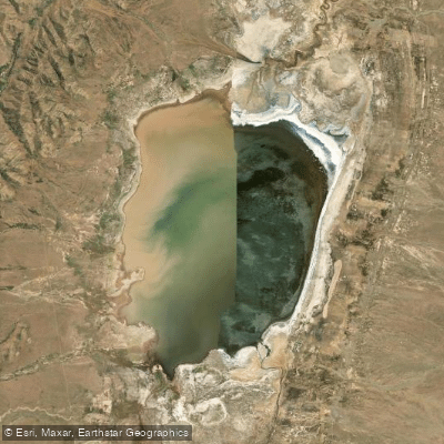
Laguna de Pozuelos
- Boat Ramps
- 0
- Access Points
- 0
- Campsites
- 0
Laguna de Pozuelos sits on the high Andean plateau of northwestern Jujuy province at an elevation of roughly 3,600 to 4,000 meters above sea level, making altitude acclimatization an essential consideration before any visit. The lagoon covers approximately 7,000 hectares when full, though its extent fluctuates considerably with summer rainfall, and complete drying has occurred during prolonged droughts. The water is alkaline and saline, with a maximum depth of only about one meter at its center — conditions that make it extremely shallow throughout. The main tributaries feeding the lagoon are the Río Cincel and the Río Santa Catalina.
The single official access point is located at the southeast corner of the reserve, where a park ranger station marks the start of an internal 7-kilometer road leading toward the shoreline. To reach this point from San Salvador de Jujuy, travelers drive north along Ruta Nacional 9 to Abra Pampa, then take Ruta Provincial 7 to the ranger station. Roads in the area are improved gravel and can be dusty; summer rainfall can affect road conditions significantly, so checking conditions before travel during that season is advisable. There are no fuel stations within the reserve — the nearest is in Rinconada — so arriving with a full tank is necessary.
The climate is dry and high-altitude, with extreme temperature swings between day and night. Warm clothing suitable for significant temperature changes is strongly recommended. The area also has naturally elevated arsenic levels in the water, compounded in some areas by historical mining activity that has contaminated tributary rivers.
The reserve is administered by Argentina's National Parks Administration and is open to the public free of charge. The park office is located in Abra Pampa. The lagoon and surrounding wetland hold multiple international designations: a UNESCO Biosphere Reserve, a Ramsar Wetland of International Importance, and an Important Bird Area. It is part of the Western Hemisphere Shorebird Reserve Network.
Wildlife is the primary draw. The lagoon supports around 130 bird species, including all three flamingo species found in Argentina, with concentrations that can exceed 100,000 individuals. Other notable species include the giant coot, Andean avocet, and Puna plover. Summer brings migratory visitors from the northern hemisphere. Given the extreme shallowness of the water and its protected status, paddling is not a practical or appropriate activity here; wildlife observation from shore is the standard visitor experience.
Water access, boat ramps & amenities
Learn how to get on Laguna de Pozuelos. Uncover great paddling access points, boat ramps, and all the facilities you need for an unforgettable day on the water. Some locations shown may border or include private property. Always check property boundaries and applicable regulations before visiting. PaddleWays's Public & Private Land layer can help you plan your access with confidence.
Paddle smarter with real-time insights
Whether you're en route and conditions shift or you're looking for the best spot based on current flows, we enable you to make informed decisions on the fly.







Jujuy licenses and regulations

Find Places to Paddle

Over 400,000 Places to Paddle
Every user gets free access to launch points, boat ramps, and public property parcels.


Water and weather conditions (10 day forecast)
See the best times to paddle Laguna de Pozuelos and check the forecast before you go.
No forecast data available.
Paddling near Laguna de Pozuelos
Explore Jujuy waters
Top paddling waters
No waters available right now.
Popular Cities
Loading popular cities...
Explore near Laguna de Pozuelos
Nearby waters
More in Jujuy

Smarter Paddling Starts in the App.
Paddleways gives you everything you need to plan smarter, paddle better, and own every trip from first launch to takeout.