Laguna Urre Lauquen
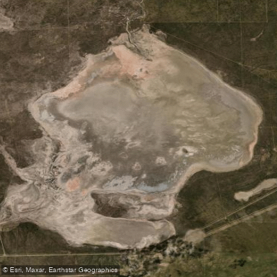
Laguna Urre Lauquen
- Boat Ramps
- 0
- Access Points
- 0
- Campsites
- 0
Laguna Urre Lauquen lies in the western part of La Pampa province, within the Departamento Curacó, at an elevation of 219 meters above sea level. Its name derives from the Mapudungun words for "mist" and "lake," translating roughly to "Lake of the Mist," a name rooted in Mapuche legend associated with the area. The laguna is fed and drained by the Río Salado, also known locally as the Chadileuvú upstream and the Curacó downstream, placing it within a broader fluvial system that crosses the Monte de llanuras y mesetas ecoregion.
The lake is notably shallow, with a mean depth of 1.6 meters and a recorded volume of approximately 152 million cubic meters. Surface area measurements indicate an extent of roughly 34 to 95 square kilometers, with dimensions of about 7.9 km north to south and 9.2 km east to west. The surrounding area is very sparsely populated.
A critical concern for any paddler planning a visit is the lake's documented vulnerability to drying. In November 2020, Laguna Urre Lauquen dried up entirely, an event attributed to a combination of reduced rainfall and upstream water management practices affecting the flow of the Chadileuvú. This represents a serious planning consideration, as water levels can be severely affected by both drought conditions and upstream diversions, potentially rendering the lake unnavigable.
The regional climate is characterized as cold and dry, with an average annual temperature of 17°C. January is the warmest month, reaching around 30°C, while July is the coldest at approximately 2°C. Average annual rainfall is 665 mm, with April being the wettest month (around 98 mm) and July the driest (around 13 mm). Anyone planning a paddle trip should verify current water levels well in advance, given the lake's history of complete desiccation.
Water access, boat ramps & amenities
Learn how to get on Laguna Urre Lauquen. Uncover great paddling access points, boat ramps, and all the facilities you need for an unforgettable day on the water. Some locations shown may border or include private property. Always check property boundaries and applicable regulations before visiting. PaddleWays's Public & Private Land layer can help you plan your access with confidence.
Paddle smarter with real-time insights
Whether you're en route and conditions shift or you're looking for the best spot based on current flows, we enable you to make informed decisions on the fly.







La Pampa licenses and regulations

Find Places to Paddle

Over 400,000 Places to Paddle
Every user gets free access to launch points, boat ramps, and public property parcels.


Water and weather conditions (10 day forecast)
See the best times to paddle Laguna Urre Lauquen and check the forecast before you go.
No forecast data available.
Paddling near Laguna Urre Lauquen
Explore La Pampa waters
Top paddling waters
No waters available right now.
Popular Cities
Loading popular cities...
Explore near Laguna Urre Lauquen
Nearby waters
More in La Pampa

Smarter Paddling Starts in the App.
Paddleways gives you everything you need to plan smarter, paddle better, and own every trip from first launch to takeout.