East Alligator River
- Saltwater
- Estuary
East Alligator River
- Saltwater
- Estuary
- Sq. miles
- 175
- Boat Ramps
- 0
- Access Points
- 0
- Campsites
- 0
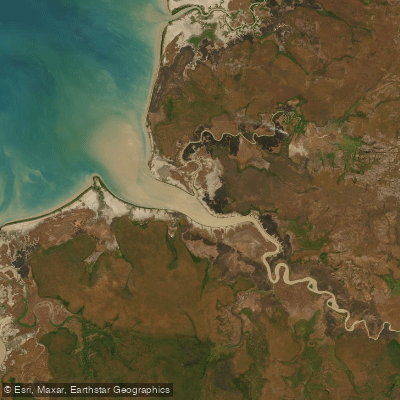
The East Alligator River is a significant tidal estuary approximately 160 kilometers long, forming the boundary between Kakadu National Park and Arnhem Land in Australia's Northern Territory. It is a saltwater system with a substantial tidal range, and its character is defined by meandering courses, fertile banks, and a remote, wild setting. Paddling here is a remote wilderness experience with a strong cultural undercurrent, as the river is central to the Aboriginal cultural landscape. The primary and most prominent access point for paddlers is at Cahills Crossing, where a concrete causeway and an upstream boat ramp are located. This site also features multiple elevated viewing platforms and a picnic area, providing the only formal facilities in the area. The crossing itself is a major focal point, especially from July through October, when dozens of estuarine crocodiles congregate to feed on fish pushed over the causeway by large tides. This presents an extreme and constant hazard; standing near the water's edge, wading, or swimming is life-threatening. Paddlers must maintain a safe distance from the bank at all times. The tidal dynamics are critical for trip planning. Large tides push muddy water and baitfish upstream, creating strong currents. Rangers recommend checking tide times before any visit, as the best wildlife viewing coincides with the tide pushing in over the crossing. For a serene paddling experience, dawn or dusk are suitable times. The river is part of Kakadu National Park, so a park entry pass is required. Access to the Arnhem Land side of the river at Gunbalanya requires a separate permit from the Northern Land Council. The water reflects the changing skies, but can be muddy, especially on a pushing tide. The surrounding landscape includes rock art galleries like Ubirr, and cultural tours such as the Guluyambi Cultural Cruise operate on the river during the dry season.
Water access, boat ramps & amenities
Learn how to get on East Alligator River. Uncover great paddling access points, boat ramps, and all the facilities you need for an unforgettable day on the water. Some locations shown may border or include private property. Always check property boundaries and applicable regulations before visiting. PaddleWays's Public & Private Land layer can help you plan your access with confidence.
Paddle smarter with real-time insights
Whether you're en route and conditions shift or you're looking for the best spot based on current flows, we enable you to make informed decisions on the fly.







Northern Territory licenses and regulations

Find Places to Paddle

Over 400,000 Places to Paddle
Every user gets free access to launch points, boat ramps, and public property parcels.


Tides, wind & water conditions (10 day forecast)
On open water, wind and tide matter as much as the weather. See the best times to paddle East Alligator River and check the marine forecast before you launch.
Loading tide predictions…
Paddling near East Alligator River
Explore Northern Territory waters
Top paddling waters
No waters available right now.
Popular Cities
Loading popular cities...
Explore near East Alligator River
Nearby waters
More in Northern Territory

Smarter Paddling Starts in the App.
Paddleways gives you everything you need to plan smarter, paddle better, and own every trip from first launch to takeout.