Boya Lake
Boya Lake
- Boat Ramps
- 1
- Access Points
- 0
- Campsites
- 1
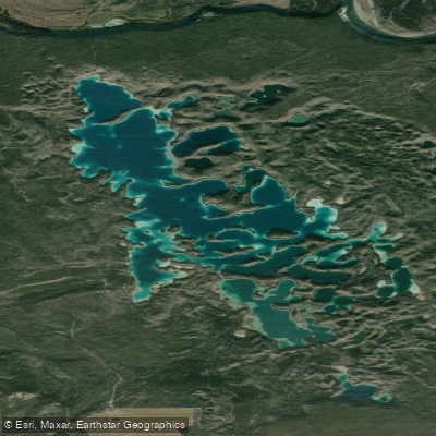
Boya Lake sits within Tā Ch'ilā Provincial Park in northern British Columbia, located about 150 km north of Dease Lake and roughly 81 km south of the Alaska Highway junction, accessible via a 2 km access road east of Highway 37. The park covers 4,597 hectares, and the lake itself is characterized by a highly convoluted shoreline with numerous peninsulas and bays that create the appearance of many islands — a feature that once earned it the name Puzzle Lake. What appear to be separate islands are often landmasses connected to shore by narrow necks of land, with channels running between them.
The lake's most distinctive visual quality is its color, which shifts between deep blue and vibrant aquamarine depending on water depth and lighting conditions. This results from light reflecting off a marl bottom composed of silt and shell fragments, which also gives the water exceptional clarity — fish are visible swimming below the surface. The lake is one of the few in northern BC that warms sufficiently for swimming during summer months.
Paddling conditions are generally calm and suitable for canoes, kayaks, and stand-up paddleboards. The many bays and channels make for interesting exploration without demanding technical skill. Canoe and kayak rentals are available through the park operator. A boat ramp is on site, along with a dock at the day-use area. The campground offers approximately 50 sites, including RV and tent sites, some positioned directly on the lake. Facilities include picnic tables, fire rings, fresh water, a picnic shelter, and a playground.
Fish species present include lake char, round whitefish, burbot, northern suckers, and sculpins. Wildlife in the area includes beavers, which are visible in the water near their lodges. Two short interpretive walking trails, each approximately 1.5 km, run at either end of the lake and provide context on the area's ecology and geology.
Backcountry or island camping is not permitted within the park; the management plan restricts camping to designated front-country sites only. There are no lifeguards on duty. Paddlers intending to fish should note that access to fishing licence vendors along the Highway 37 corridor is limited, and obtaining a BC Freshwater Fishing Licence online before arriving is recommended.
Water access, boat ramps & amenities
Learn how to get on Boya Lake. Uncover great paddling access points, boat ramps, and all the facilities you need for an unforgettable day on the water. Some locations shown may border or include private property. Always check property boundaries and applicable regulations before visiting. PaddleWays's Public & Private Land layer can help you plan your access with confidence.
Paddle smarter with real-time insights
Whether you're en route and conditions shift or you're looking for the best spot based on current flows, we enable you to make informed decisions on the fly.







Bc licenses and regulations
No licenses or regulations available for Bc.
Find Places to Paddle

Over 400,000 Places to Paddle
Every user gets free access to launch points, boat ramps, and public property parcels.


Water and weather conditions (10 day forecast)
See the best times to paddle Boya Lake and check the forecast before you go.
No forecast data available.
Explore Bc waters
Top paddling waters
No waters available right now.
Popular Cities
Loading popular cities...
Explore near Boya Lake
Nearby waters
More in Bc

Smarter Paddling Starts in the App.
Paddleways gives you everything you need to plan smarter, paddle better, and own every trip from first launch to takeout.