Laguna Verde
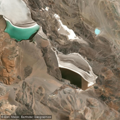
Laguna Verde
- Boat Ramps
- 0
- Access Points
- 0
- Campsites
- 0
Laguna Verde sits at approximately 4,090–4,100 meters above sea level in the western portion of the Tinogasta department of Catamarca province, Argentina. It occupies the floor of an endorheic basin — a closed drainage system with no outlet — and is part of the broader Salina de la Laguna Verde complex. The lake lies close to the Paso de San Francisco and the less-accessible Paso Tres Quebradas, both of which connect to Chile.
Paddling on Laguna Verde is not permitted. Provincial tourism authorities explicitly state that the laguna is not suitable for navigation or swimming, citing its delicate natural equilibrium and the sensitive ecological conditions that give the water its distinctive coloration. The color results from the interaction of minerals, microorganisms, and high-altitude light. Visiting the lake as a visual destination is the recommended approach.
Access requires leaving Ruta Nacional 60 at Pastos Largos — reachable from Tinogasta at km 1321 or from Fiambalá at km 1369. A Vialidad road maintenance camp at Pastos Largos is a useful stop to check road conditions before proceeding. The route continues through the Valle del Chaschuil, past a Guanaco Reserve, a Gendarmería checkpoint at Cortaderas, and a provincial police post at Laguna Verde itself. Camping is available at the police post location.
Given the high altitude, remoteness, and restricted access to the water, anyone traveling to this area should plan accordingly for extreme conditions typical of the Andean puna environment.
Water access, boat ramps & amenities
Learn how to get on Laguna Verde. Uncover great paddling access points, boat ramps, and all the facilities you need for an unforgettable day on the water. Some locations shown may border or include private property. Always check property boundaries and applicable regulations before visiting. PaddleWays's Public & Private Land layer can help you plan your access with confidence.
Paddle smarter with real-time insights
Whether you're en route and conditions shift or you're looking for the best spot based on current flows, we enable you to make informed decisions on the fly.







Catamarca licenses and regulations

Find Places to Paddle

Over 400,000 Places to Paddle
Every user gets free access to launch points, boat ramps, and public property parcels.


Water and weather conditions (10 day forecast)
See the best times to paddle Laguna Verde and check the forecast before you go.
No forecast data available.
Paddling near Laguna Verde
Explore Catamarca waters
Top paddling waters
No waters available right now.
Popular Cities
Loading popular cities...
Explore near Laguna Verde
Nearby waters
More in Catamarca

Smarter Paddling Starts in the App.
Paddleways gives you everything you need to plan smarter, paddle better, and own every trip from first launch to takeout.