Lago Musters
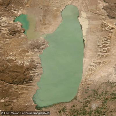
Lago Musters
- Boat Ramps
- 0
- Access Points
- 0
- Campsites
- 1
Lago Musters sits in the Valle de Sarmiento in the south of Chubut province, at an elevation of 271 meters above sea level. It covers a surface area of 342 km², making it a substantial body of water in the central Patagonian steppe. The lake has an average depth of 15 meters and reaches a maximum depth of 38.5 meters, with a total water volume of 8.28 km³. Its primary inflow is the Senguerr River, and the basin is endorheic — meaning the lake has no permanent surface outflow, though it connects with the nearby Lago Colhué Huapi as part of the same terminal basin system.
The lake's size and open exposure in the Patagonian steppe mean wind is a significant factor for anyone on the water. Windsurfing is practiced here, which reflects the consistent wind conditions typical of the region and is an important consideration for paddlers assessing safety and route planning. The nearest settlement is Colonia Sarmiento, which also serves as the primary access point for the area.
Sport fishing is practiced on the lake, with rainbow trout and brown trout among the species present. The lake also functions as a drinking water source for several regional towns including Comodoro Rivadavia and Colonia Sarmiento, which may have implications for water quality and any applicable use regulations.
The lake was historically known as 'Otrón' by the Tehuelche people (Aonikenk), the former inhabitants of the region, giving it a layer of cultural and historical significance within the broader Patagonian landscape.
Water access, boat ramps & amenities
Learn how to get on Lago Musters. Uncover great paddling access points, boat ramps, and all the facilities you need for an unforgettable day on the water. Some locations shown may border or include private property. Always check property boundaries and applicable regulations before visiting. PaddleWays's Public & Private Land layer can help you plan your access with confidence.
Paddle smarter with real-time insights
Whether you're en route and conditions shift or you're looking for the best spot based on current flows, we enable you to make informed decisions on the fly.







Chubut licenses and regulations

Find Places to Paddle

Over 400,000 Places to Paddle
Every user gets free access to launch points, boat ramps, and public property parcels.


Water and weather conditions (10 day forecast)
See the best times to paddle Lago Musters and check the forecast before you go.
Lago Muster - Fortín
Explore Chubut waters
Top paddling waters
No waters available right now.
Popular Cities
Loading popular cities...
Explore near Lago Musters

Smarter Paddling Starts in the App.
Paddleways gives you everything you need to plan smarter, paddle better, and own every trip from first launch to takeout.