Arnhem Bay
- Saltwater
- Estuary
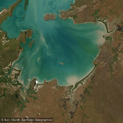
Arnhem Bay
- Saltwater
- Estuary
- Sq. miles
- 587
- Boat Ramps
- 0
- Access Points
- 0
- Campsites
- 0
Arnhem Bay is a coastal estuary located in East Arnhem Land, Northern Territory, Australia. It is a significant body of water within the broader marine environment of the Arafura Sea. The bay is situated near the Indigenous community of Nyinyikay and is within the region of Gove and Nhulunbuy. Access to the water for paddlers is primarily via boat ramps, with a high-capacity triple-lane concrete boat launch ramp in the area. Other potential access points for boat launching are located at Dhälinybuy, Bukudal, and Garrthalala. The area holds deep cultural significance, with references to sacred sites and creation stories, such as those depicted by artist Mawalan Marika, and stone picture sites are located at Hardy Island within the bay. The region is part of Arnhem Land, which requires permits for visitors, indicating that paddlers must secure appropriate permissions before accessing the area. The bay experiences significant tidal influence as part of a navigable tidal river system extending into it, meaning paddlers must plan for strong tidal currents. The marine environment supports wildlife including barramundi and Port Jackson sharks. The aesthetic is that of a remote tropical estuary, with mangrove creek systems noted along its shores. Given its exposure to the Arafura Sea, paddlers should expect potential for wind and open water conditions within the bay.
Water access, boat ramps & amenities
Learn how to get on Arnhem Bay. Uncover great paddling access points, boat ramps, and all the facilities you need for an unforgettable day on the water. Some locations shown may border or include private property. Always check property boundaries and applicable regulations before visiting. PaddleWays's Public & Private Land layer can help you plan your access with confidence.
Paddle smarter with real-time insights
Whether you're en route and conditions shift or you're looking for the best spot based on current flows, we enable you to make informed decisions on the fly.







Northern Territory licenses and regulations

Find Places to Paddle

Over 400,000 Places to Paddle
Every user gets free access to launch points, boat ramps, and public property parcels.


Tides, wind & water conditions (10 day forecast)
On open water, wind and tide matter as much as the weather. See the best times to paddle Arnhem Bay and check the marine forecast before you launch.
Loading tide predictions…
Explore Northern Territory waters
Top paddling waters
No waters available right now.
Popular Cities
Loading popular cities...
Explore near Arnhem Bay
Nearby waters
More in Northern Territory

Smarter Paddling Starts in the App.
Paddleways gives you everything you need to plan smarter, paddle better, and own every trip from first launch to takeout.