Cato River
- Saltwater
- Estuary
Cato River
- Saltwater
- Estuary
- Sq. miles
- 19
- Boat Ramps
- 0
- Access Points
- 0
- Campsites
- 0
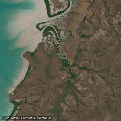
The Cato River is a tidal estuary located in the remote East Arnhem Region of Australia's Northern Territory. The primary access point for paddlers is the Cato River Campground, also referred to as the Cato River Recreational Area, which is operated by the Liya Wanhurr Aboriginal Corporation and is located close to the Dhalinybuy homeland. This campground provides a base for day use and is the complimentary campsite associated with local cultural tours. The river flows into Arnhem Bay, and its mouth opens into the ocean. This is a saltwater environment with significant and active crocodile populations. A notable safety incident involved a five-metre saltwater crocodile aggressively attacking moored boats on the river, demonstrating that crocodiles in this area can be large, territorial, and pose a serious threat to paddlers, especially during breeding season or when boats are stationary. The area is culturally significant to the Yolŋu people, and the river flows through Wangurri country. The surrounding landscape is rugged, requiring a 4WD vehicle for access. The river is a perennial waterbody. Nearby attractions include the Bindawuy Waterfall Recreational Area, which features a freshwater waterfall, but this is a separate land-based site accessible from the campground, not a feature of the river itself. Given the remote location and the presence of large, potentially aggressive crocodiles, any paddling activity on the Cato River must be undertaken with extreme caution and a thorough understanding of crocodile safety protocols.
Water access, boat ramps & amenities
Learn how to get on Cato River. Uncover great paddling access points, boat ramps, and all the facilities you need for an unforgettable day on the water. Some locations shown may border or include private property. Always check property boundaries and applicable regulations before visiting. PaddleWays's Public & Private Land layer can help you plan your access with confidence.
Paddle smarter with real-time insights
Whether you're en route and conditions shift or you're looking for the best spot based on current flows, we enable you to make informed decisions on the fly.







Northern Territory licenses and regulations

Find Places to Paddle

Over 400,000 Places to Paddle
Every user gets free access to launch points, boat ramps, and public property parcels.


Tides, wind & water conditions (10 day forecast)
On open water, wind and tide matter as much as the weather. See the best times to paddle Cato River and check the marine forecast before you launch.
Loading tide predictions…
Explore Northern Territory waters
Top paddling waters
No waters available right now.
Popular Cities
Loading popular cities...
Explore near Cato River
Nearby waters
More in Northern Territory

Smarter Paddling Starts in the App.
Paddleways gives you everything you need to plan smarter, paddle better, and own every trip from first launch to takeout.