Glyde River
- Saltwater
- Estuary
Glyde River
- Saltwater
- Estuary
- Sq. miles
- 48
- Boat Ramps
- 0
- Access Points
- 0
- Campsites
- 0
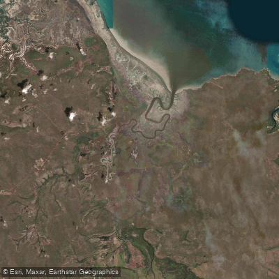
The Glyde River is a coastal estuary flowing north from the Arafura Swamp to the Arafura Sea in the East Arnhem Region of Australia's Northern Territory. It is a culturally significant waterway for the Yolngu people, with its path through the swamp to the sea holding deep meaning. The river's character is defined by its connection to Gurruwiling, the Arafura Swamp, which is the largest freshwater ecosystem in Arnhem Land. The river serves as the primary overflow channel from this vast paperbark swamp system to the ocean. This creates a dynamic environment transitioning from inland freshwater wetlands through estuarine reaches to a coastal marine zone. The surrounding landscape includes extensive woodlands, patches of rainforest, and coastal features like mangroves, beaches, and reefs.
Paddling here offers a journey through a rich cultural and ecological landscape. The area supports a high diversity of plant, fish, bird, and animal species, with the swamp alone supporting hundreds of thousands of birds. Historically, the river and adjacent swamp were used for hunting and fishing, with Indigenous watercraft specifically modified for navigating the shallow flooded grasslands during the wet season and the open river reaches. The region is entirely owned by Aboriginal people and is subject to the customary laws and marine tenure of the Traditional Custodians. Access for paddling is therefore not a simple matter of public right; it requires appropriate permissions and respect for this private land and sea country. There are no public boat ramps, designated launches, or facilities for visitors. Any paddling trip would require extensive prior planning, consultation with the Northern Land Council and relevant Traditional Owner groups, and likely the services of an authorized guide. The experience would be one of remote wilderness paddling in a region of profound cultural significance, where the health of the environment and the practices of the people are deeply interconnected.
Water access, boat ramps & amenities
Learn how to get on Glyde River. Uncover great paddling access points, boat ramps, and all the facilities you need for an unforgettable day on the water. Some locations shown may border or include private property. Always check property boundaries and applicable regulations before visiting. PaddleWays's Public & Private Land layer can help you plan your access with confidence.
Paddle smarter with real-time insights
Whether you're en route and conditions shift or you're looking for the best spot based on current flows, we enable you to make informed decisions on the fly.







Northern Territory licenses and regulations

Find Places to Paddle

Over 400,000 Places to Paddle
Every user gets free access to launch points, boat ramps, and public property parcels.


Tides, wind & water conditions (10 day forecast)
On open water, wind and tide matter as much as the weather. See the best times to paddle Glyde River and check the marine forecast before you launch.
Loading tide predictions…
Paddling near Glyde River
Explore Northern Territory waters
Top paddling waters
No waters available right now.
Popular Cities
Loading popular cities...
Explore near Glyde River
Nearby waters
More in Northern Territory

Smarter Paddling Starts in the App.
Paddleways gives you everything you need to plan smarter, paddle better, and own every trip from first launch to takeout.