Represa Foz Do Areia
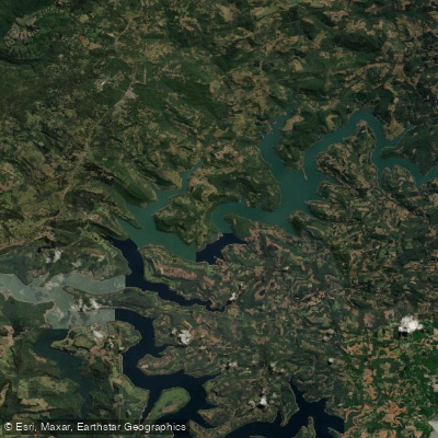
Represa Foz Do Areia
- Boat Ramps
- 0
- Access Points
- 0
- Campsites
- 1
Represa Foz do Areia, officially known as Usina Governador Bento Munhoz da Rocha Netto, is a large hydroelectric reservoir formed on the Rio Iguaçu in the state of Paraná, Brazil. The dam, owned by the utility COPEL, has a wall 828 meters long and 160 meters high, and construction began in 1975 with commercial operation starting in 1980. The reservoir covers approximately 167 km² of water surface at a maximum elevation of 774 meters above sea level, making it one of the largest impoundments in Paraná.
The reservoir sits at roughly 753 meters altitude and spans the municipalities of Pinhão, Bituruna, and Cruz Machado, approximately 280–320 kilometers from Curitiba. The standard route from Curitiba follows the BR-277 to Guarapuava (about 250 km) and then the PR-170 toward Pinhão (about 80 km), with final access via rural roads. These unpaved roads can deteriorate significantly during rainy periods, so carrying extra fuel and supplies is advisable. The reservoir is large enough that first-time visitors are encouraged to go with a local guide, as there are multiple access points spread around its perimeter.
The surrounding landscape is characterized by native forest and numerous arms and coves formed by the irregular shoreline of the impoundment. These inlets create varied paddling terrain and provide habitat for fish species including tucunaré, tilápia, and traíra. Support infrastructure around the reservoir is still developing, though accommodation options exist in nearby Pinhão. Environmental enforcement is active in the area; illegal fishing has resulted in arrests by the Polícia Militar Ambiental, indicating that regulations on the water are monitored and enforced. Paddlers should be aware of this regulatory presence and confirm any specific rules regarding watercraft use before launching.
The scale of the reservoir — over 150 km² — means that open-water crossings can expose paddlers to wind and wave conditions typical of large inland lakes. The combination of extensive shoreline, native vegetation, and the dramatic dam structure gives the water body a distinctly remote character, though the relative lack of developed facilities means self-sufficiency is important for any paddling trip here.
Water access, boat ramps & amenities
Learn how to get on Represa Foz Do Areia. Uncover great paddling access points, boat ramps, and all the facilities you need for an unforgettable day on the water. Some locations shown may border or include private property. Always check property boundaries and applicable regulations before visiting. PaddleWays's Public & Private Land layer can help you plan your access with confidence.
Paddle smarter with real-time insights
Whether you're en route and conditions shift or you're looking for the best spot based on current flows, we enable you to make informed decisions on the fly.







Paraná licenses and regulations
No licenses or regulations available for Paraná.
Find Places to Paddle

Over 400,000 Places to Paddle
Every user gets free access to launch points, boat ramps, and public property parcels.


Water and weather conditions (10 day forecast)
See the best times to paddle Represa Foz Do Areia and check the forecast before you go.
Uhe Foz Do Areia Reservatório
All Flow Stations
Paddling near Represa Foz Do Areia
Rio Socorro
Rio Iguaçu
Rio Turvo
Rio Cavernoso
Rio Turvo
Rio São Sebastião
Rio Cachoeira
Rio do Corvo
Rio dos Papagaios
Explore Paraná waters
Top paddling waters
No waters available right now.
Popular Cities
Loading popular cities...
Explore near Represa Foz Do Areia
Access points
Nearby waters
More in Paraná

Smarter Paddling Starts in the App.
Paddleways gives you everything you need to plan smarter, paddle better, and own every trip from first launch to takeout.