Rio Ipojuca
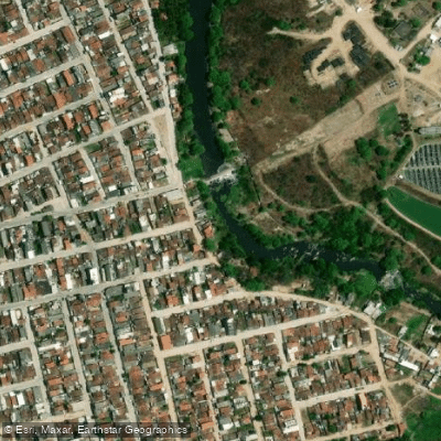
Rio Ipojuca
- Boat Ramps
- 0
- Access Points
- 0
- Campsites
- 1
The Rio Ipojuca flows through Pernambuco, Brazil, reaching the sea near the municipality of Ipojuca in the district of Nossa Senhora do Ó, on the southern coast of the state. The mouth of the river lies less than 10 kilometers from Porto de Galinhas beach, making it a practical destination for paddlers based along that stretch of coastline.
Near its mouth, the river widens considerably and is flanked by mangroves, sandbanks, and branching channels. These mangrove branches extend off the main channel and provide sheltered, shallower water. The surrounding landscape is notably different from other rivers in the region, with varied natural scenery along the banks and no buildings or structures visible from the water, giving the area a relatively remote character despite its proximity to a popular tourist destination.
The river is used for subsistence fishing and shellfish extraction by local communities, which is worth keeping in mind when planning routes, particularly near the mouth where activity is concentrated. Fishing from boats is the primary on-water activity in this stretch, with anglers targeting tarpons (locally called pirapema) and sea bass in the deeper channels. During low tide, sandbanks are exposed at certain points, which affects navigation and depth in shallower areas.
Tarpons are frequently observed rolling at the surface, and sea bass concentrate in the deeper channel sections. The mangrove habitat supports shellfish populations and provides structure for fish, indicating a reasonably healthy estuarine ecosystem in this lower reach of the river.
The tidal influence near the mouth means water depth and current direction will vary with the tide cycle, and low tide exposes sandbanks that can restrict passage in some areas. Paddlers should account for tidal timing when planning trips in the lower estuary section.
Water access, boat ramps & amenities
Learn how to get on Rio Ipojuca. Uncover great paddling access points, boat ramps, and all the facilities you need for an unforgettable day on the water. Some locations shown may border or include private property. Always check property boundaries and applicable regulations before visiting. PaddleWays's Public & Private Land layer can help you plan your access with confidence.
Paddle smarter with real-time insights
Whether you're en route and conditions shift or you're looking for the best spot based on current flows, we enable you to make informed decisions on the fly.







Pernambuco licenses and regulations
No licenses or regulations available for Pernambuco.
Find Places to Paddle

Over 400,000 Places to Paddle
Every user gets free access to launch points, boat ramps, and public property parcels.


Water and weather conditions (10 day forecast)
See the best times to paddle Rio Ipojuca and check the forecast before you go.
Sanharó
All Flow Stations
Explore Pernambuco waters
Top paddling waters
No waters available right now.
Popular Cities
Loading popular cities...
Explore near Rio Ipojuca
Access points
Nearby waters
More in Pernambuco

Smarter Paddling Starts in the App.
Paddleways gives you everything you need to plan smarter, paddle better, and own every trip from first launch to takeout.