Driekoppies Dam
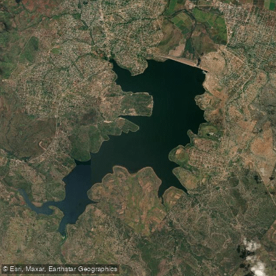
Driekoppies Dam
- Boat Ramps
- 0
- Access Points
- 0
- Campsites
- 0
Driekoppies Dam is a gravity/earth-fill dam on the Lomati River, located near Malelane in Mpumalanga, South Africa, close to the southern boundary of Kruger National Park and near the Swazi border. Completed in 1998 and operated primarily for irrigation purposes, the reservoir — known as Lake Matsamo — covers approximately 1,870 hectares with a total storage capacity of 251 million cubic metres. The dam wall stands 50 metres high and extends 2,340 metres in length, creating a substantial open-water environment.
The water quality at Driekoppies has been described as crystal clear, at least in the shallower areas along the shoreline. The reservoir is large enough to support motorised boat use, and a boat launch facility appears to be available on site. Access through a gate is controlled, and visitors have noted the presence of an informal car wash and security service near the launch area, which provides some reassurance regarding vehicle safety while out on the water.
Boat cruises operate on the dam, and the site has been used for leisure activities including camping, music events, and 4x4 activities, suggesting a degree of recreational infrastructure in the area. The reservoir's size — with roughly 1,000 additional acres mapped in survey updates around 2019 — indicates substantial open water suitable for extended paddling trips. Bathymetric survey data has been produced for the dam, which may be of use to paddlers navigating the deeper sections.
Bass fishing is a well-established activity at the dam, with anglers noting that a boat is essentially necessary to access the more productive areas away from the grassy shallows near the shoreline. The surrounding landscape places the dam within the broader Lowveld environment of Mpumalanga, south of Kruger National Park, which suggests the possibility of encountering wildlife typical of that region. No specific paddling restrictions have been identified, though access through a gate implies some level of site management that paddlers should confirm before visiting.
Water access, boat ramps & amenities
Learn how to get on Driekoppies Dam. Uncover great paddling access points, boat ramps, and all the facilities you need for an unforgettable day on the water. Some locations shown may border or include private property. Always check property boundaries and applicable regulations before visiting. PaddleWays's Public & Private Land layer can help you plan your access with confidence.
Paddle smarter with real-time insights
Whether you're en route and conditions shift or you're looking for the best spot based on current flows, we enable you to make informed decisions on the fly.








Find Places to Paddle

Over 400,000 Places to Paddle
Every user gets free access to launch points, boat ramps, and public property parcels.


Water and weather conditions (10 day forecast)
See the best times to paddle Driekoppies Dam and check the forecast before you go.
No forecast data available.
Paddling near Driekoppies Dam
Explore Mpumalanga waters
Top paddling waters
No waters available right now.
Popular Cities
Loading popular cities...
Explore near Driekoppies Dam
More in Mpumalanga

Smarter Paddling Starts in the App.
Paddleways gives you everything you need to plan smarter, paddle better, and own every trip from first launch to takeout.