Lake Claire
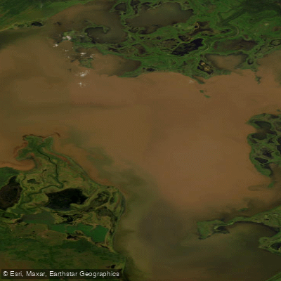
Lake Claire
- Boat Ramps
- 0
- Access Points
- 0
- Campsites
- 0
Lake Claire is the largest lake located entirely within Alberta, covering 1,436 km² with a maximum length of 59 km and maximum width of 45 km. It sits at an elevation of 213 m within Wood Buffalo National Park, positioned between the mouths of the Peace River to the north and the Athabasca River to the south, forming a central part of the Peace-Athabasca Delta system. The lake is fed primarily by the Birch River and McIvor River, and its waters discharge into the Peace River, eventually draining to the Arctic Ocean via the Slave River, Great Slave Lake, and Mackenzie River. The lake system also encompasses Baril Lake and Mamawi Lake, and the lake itself contains approximately 21 km² of island area.
Access is a defining challenge for any paddling trip here. There are no roads leading to or from Lake Claire, making it accessible only by boat, canoe, or floatplane. Fort Chipewyan, located to the southwest, serves as the nearest community and practical staging point. One documented canoe route passes through the area via the Peace River corridor, with Sweetgrass Landing and Sweetgrass Station accessible by trail from the river, offering views over Lake Claire and the broader delta. The Boreal Bucketlist account of a Peace Point to Sweetgrass Station canoe trip describes the surrounding forest as alive with wildlife, with wolves and bison present in the area — a significant safety consideration for paddlers camping on shore.
Because the lake lies within Wood Buffalo National Park, paddlers should expect national park regulations to apply, including requirements around backcountry travel, camping, and wildlife encounters. The park's Indigenous communities have deep historical ties to the lake, including a longstanding fishing culture passed down through generations.
Summer is the primary season for paddling, offering the best water access and the longest daylight hours. The lake's far northern latitude — approximately 58°35′N — means winter transforms the area dramatically, and the proximity to the Arctic makes it a viable location for viewing the Aurora Borealis in the darker months, though paddling in winter conditions would be extremely hazardous. Wildlife in the region includes bison, wolves, and abundant bird life associated with the delta ecosystem.
The sheer scale of the lake, its complete lack of road access, and its position deep within a remote national park make this a serious wilderness paddling destination requiring thorough logistical planning.
Water access, boat ramps & amenities
Learn how to get on Lake Claire. Uncover great paddling access points, boat ramps, and all the facilities you need for an unforgettable day on the water. Some locations shown may border or include private property. Always check property boundaries and applicable regulations before visiting. PaddleWays's Public & Private Land layer can help you plan your access with confidence.
Paddle smarter with real-time insights
Whether you're en route and conditions shift or you're looking for the best spot based on current flows, we enable you to make informed decisions on the fly.







Ab licenses and regulations
No licenses or regulations available for Ab.
Find Places to Paddle

Over 400,000 Places to Paddle
Every user gets free access to launch points, boat ramps, and public property parcels.


Water and weather conditions (10 day forecast)
See the best times to paddle Lake Claire and check the forecast before you go.
LAKE CLAIRE NEAR OUTLET TO PRAIRIE RIVER
Paddling near Lake Claire
Explore Ab waters
Top paddling waters
No waters available right now.
Popular Cities
Loading popular cities...
Explore near Lake Claire
Nearby waters
More in Ab

Smarter Paddling Starts in the App.
Paddleways gives you everything you need to plan smarter, paddle better, and own every trip from first launch to takeout.