Glacier Lake
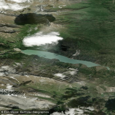
Glacier Lake
- Boat Ramps
- 0
- Access Points
- 0
- Campsites
- 0
Glacier Lake sits within Nahanni National Park Reserve in the Northwest Territories, positioned roughly 9–10 kilometres overland from the South Nahanni River and accessible on foot via a social trail from the river. The lake is approximately 5 kilometres in length, and paddlers who make the hike in will find a small number of canoes cached at the trail's end by outfitters — these are available to borrow and return. The lake serves as a designated aircraft landing site within the park, making it one of only two day-use floatplane destinations alongside Virginia Falls, with charter services typically departing from Fort Simpson.
The overland trail connecting the South Nahanni River to Glacier Lake is demanding. It passes through thick forest, is often wet, and can be difficult to distinguish from animal trails, making GPS navigation advisable. Water levels on the lake affect conditions along the shoreline: at higher water, the bush along the lake's edge becomes very thick and difficult to travel through, while lower water levels expose gravel and rock that allow easier movement. The hike is approximately 9–10 kilometres one way, and the route is not recommended for portaging canoes and heavy gear.
Wildlife is a notable consideration. The area around Glacier Lake has a high density of bears, and paddlers and hikers are advised to exercise extra caution with food storage and to make noise while travelling. A logbook is maintained at the northwest gravel bar of Glacier Lake, where visitors are encouraged to record trip details — a useful practice given the park's remote setting and the importance of search-and-rescue coordination.
The lake is dominated visually by Mt. Sir James McBrien and provides the primary access point for the Cirque of the Unclimbables, a dramatic mountain formation that draws most visitors to this corner of the park. The paddling across the lake itself is roughly 5 kilometres. As a designated landing site, Glacier Lake is also used as an emergency evacuation point for expeditions travelling the upper South Nahanni corridor. Visitors must register their itinerary with Parks Canada prior to travel, as is standard for the park reserve.
Water access, boat ramps & amenities
Learn how to get on Glacier Lake. Uncover great paddling access points, boat ramps, and all the facilities you need for an unforgettable day on the water. Some locations shown may border or include private property. Always check property boundaries and applicable regulations before visiting. PaddleWays's Public & Private Land layer can help you plan your access with confidence.
Paddle smarter with real-time insights
Whether you're en route and conditions shift or you're looking for the best spot based on current flows, we enable you to make informed decisions on the fly.







Nt licenses and regulations
No licenses or regulations available for Nt.
Find Places to Paddle

Over 400,000 Places to Paddle
Every user gets free access to launch points, boat ramps, and public property parcels.


Water and weather conditions (10 day forecast)
See the best times to paddle Glacier Lake and check the forecast before you go.
No forecast data available.
Paddling near Glacier Lake
Explore Nt waters
Top paddling waters
No waters available right now.
Popular Cities
Loading popular cities...
Explore near Glacier Lake
Nearby waters
More in Nt

Smarter Paddling Starts in the App.
Paddleways gives you everything you need to plan smarter, paddle better, and own every trip from first launch to takeout.