Riacho Monte Lindo Grande
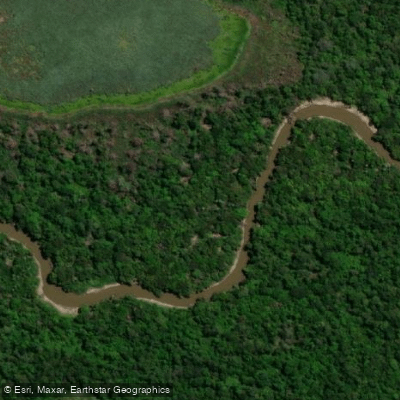
Riacho Monte Lindo Grande
- Boat Ramps
- 0
- Access Points
- 0
- Campsites
- 0
Riacho Monte Lindo Grande is a slow-moving waterway in the Provincia de Formosa, Argentina, originating near the town of Pozo del Tigre in the Departamento Patiño at an elevation of approximately 125 meters. It flows generally west to east across roughly 300 kilometers, passing through the departments of Patiño, Pirané, and Formosa before emptying into the Río Paraguay at an elevation of about 60 meters. The river is part of the Cuenca del Plata, one of the largest river systems in the world. Its tributaries include the Riacho Tatú Piré and the Riacho Monte Lindo Chico.
The channel is characterized by countless meanders across a floodplain that varies between 800 and 1,600 meters in width. The river has developed natural levees and alluvial deposits alongside paleochannels, abandoned meanders, oxbow lakes, and other landforms typical of a highly sinuous lowland river. During periods of extreme flooding on the Río Pilcomayo, water is redirected into the riacho through a 40-kilometer artificial canal, which can significantly raise water levels.
The banks are lined with dense gallery forests and impenetrable thickets representative of the Gran Chaco ecosystem, providing habitat for a wide range of flora and fauna characteristic of the region.
A well-documented multi-day paddling route runs from the area of La Loma (Monseñor D'Andrea) downstream to the city of Formosa, a journey that has taken paddlers approximately nine days by canoe or kayak. This route was featured in the Argentine outdoor magazine Weekend (issue No. 278, November 1995). A shorter organized route begins at the bridge on Ruta Nacional 11, continues down the Riacho Monte Lindo through the locality of Dalmacia, then connects to the Río Paraguay for a total trip of approximately three days ending in the city of Formosa.
Since 1990, the Municipalidad de la Ciudad de Formosa has organized an annual nautical event on the riacho each April, drawing participants from multiple Argentine provinces as well as from Paraguay. This established event confirms that April is a recognized time for paddling activity on the waterway.
Water access, boat ramps & amenities
Learn how to get on Riacho Monte Lindo Grande. Uncover great paddling access points, boat ramps, and all the facilities you need for an unforgettable day on the water. Some locations shown may border or include private property. Always check property boundaries and applicable regulations before visiting. PaddleWays's Public & Private Land layer can help you plan your access with confidence.
Paddle smarter with real-time insights
Whether you're en route and conditions shift or you're looking for the best spot based on current flows, we enable you to make informed decisions on the fly.







Formosa licenses and regulations

Find Places to Paddle

Over 400,000 Places to Paddle
Every user gets free access to launch points, boat ramps, and public property parcels.


Water and weather conditions (10 day forecast)
See the best times to paddle Riacho Monte Lindo Grande and check the forecast before you go.
No forecast data available.
Explore Formosa waters
Top paddling waters
No waters available right now.
Popular Cities
Loading popular cities...
Explore near Riacho Monte Lindo Grande
More in Formosa

Smarter Paddling Starts in the App.
Paddleways gives you everything you need to plan smarter, paddle better, and own every trip from first launch to takeout.