Laguna de Vilama
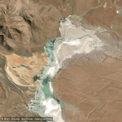
Laguna de Vilama
- Boat Ramps
- 0
- Access Points
- 0
- Campsites
- 0
Laguna de Vilama is a hypersaline salt lake situated at 4,650 meters above sea level in the Departamento Rinconada of Jujuy Province, Argentina, close to the Argentine-Bolivian border and near the tripoint with Chile at Cerro Zapaleri. It covers a surface area of approximately 4,590 hectares and sits within the Vilama caldera, occupying the floor of a high-altitude endorheic depression in the Puna region.
The most significant characteristic for any paddler to understand is the lake's extreme shallowness: the average depth is only 0.2 meters (roughly 8 inches). This makes conventional paddling impractical across most of the lake's surface. The water is hypersaline in character.
Access is via Ruta Provincial 85, an unpaved dirt road suitable only for four-wheel-drive vehicles, departing from the village of Lagunillas del Farallón and running along the eastern shore of the lake, passing through the area known as Esquina Sapahua. Lagunillas del Farallón is the last point where basic supplies can be purchased, and it offers free internet access in the plaza. There is no potable water at the lake, no cell phone signal, and no permanent staff at the nearby biological station, which has limited capacity (5 beds) and allows camping.
The extreme altitude presents a serious physiological hazard. Oxygen supplementation is recommended, particularly for those who have not previously been at 4,500 meters or above. Acclimatization in Abra Pampa for several days before ascending is strongly advised. In winter, water at the lake freezes and ice forms on the access road. In summer, flooding of rivers along the route makes access significantly more difficult; daytime travel is recommended during that season.
Laguna de Vilama is a designated Ramsar wetland site (since 2000, covering 157,000 ha) and an Important Bird Area (since 2008, covering 150,000 ha). The lake and surrounding wetlands support populations of three flamingo species including Phoenicoparrus andinus and P. jamesi, the horned coot (Fulica cornuta), vicuñas, suris, and the diademed sandpiper-plover (Phegornis mitchelli). Abandoned tin mines are present on the eastern shore, and the area has historical associations with silver and gold extraction as well as the ulexite salt obtained from the Pirquitas mine on the lake's shore.
Water access, boat ramps & amenities
Learn how to get on Laguna de Vilama. Uncover great paddling access points, boat ramps, and all the facilities you need for an unforgettable day on the water. Some locations shown may border or include private property. Always check property boundaries and applicable regulations before visiting. PaddleWays's Public & Private Land layer can help you plan your access with confidence.
Paddle smarter with real-time insights
Whether you're en route and conditions shift or you're looking for the best spot based on current flows, we enable you to make informed decisions on the fly.







Jujuy licenses and regulations

Find Places to Paddle

Over 400,000 Places to Paddle
Every user gets free access to launch points, boat ramps, and public property parcels.


Water and weather conditions (10 day forecast)
See the best times to paddle Laguna de Vilama and check the forecast before you go.
No forecast data available.
Explore Jujuy waters
Top paddling waters
No waters available right now.
Popular Cities
Loading popular cities...
Explore near Laguna de Vilama
More in Jujuy

Smarter Paddling Starts in the App.
Paddleways gives you everything you need to plan smarter, paddle better, and own every trip from first launch to takeout.