Moora Moora Reservoir
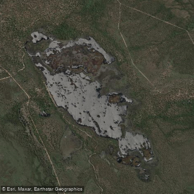
Moora Moora Reservoir
- Boat Ramps
- 0
- Access Points
- 0
- Campsites
- 0
Moora Moora Reservoir is a small reservoir situated in the heart of the Grampians National Park in Victoria, within the upper reaches of the Glenelg River catchment. When at full supply, the reservoir covers a surface area of approximately 4.1 square kilometres (280 hectares), with a maximum depth of only 2.2 metres, making it a notably shallow water body. It was constructed in 1934 and serves as the primary water supply for Supply System 6 of the Wimmera Mallee Pipeline. The reservoir is fed principally by Moora Moora Creek and Castle Creek, and can also receive water via transfers from the upper Glenelg River along the Moora Inlet Channel.
For paddlers, the reservoir offers a varied character across its extent. The northern end features a complex arrangement of reed islands and floating aquatic vegetation, creating a maze-like network of narrow waterways that can be disorienting to navigate. The southern end opens into more expansive, unobstructed water. Paddlers should be aware that the intricate layout of the northern section makes it easy to lose one's bearings, and using a navigation or tracking application is advisable before venturing into that area.
Boating is permitted year-round, subject to a strict 5-knot speed limit. Internal combustion engines are banned, and powerboats are not permitted on the reservoir. Water skiing and jet skis are also prohibited. Swimming is permitted. Dogs are not allowed at the reservoir. Duck shooting is not permitted. The boating authority for Moora Moora Reservoir is GWMWater.
Camping is permitted adjacent to the main embankment. Campfires are allowed in properly constructed fireplaces, subject to Country Fire Authority warnings and restrictions, and must be fully extinguished with water before departure.
The reservoir is noted for its abundant birdlife and the mountain backdrop visible in multiple directions. Fish species recorded in the reservoir include European perch, inanga, and tench. The surrounding landscape is within Grampians National Park, providing an undeveloped natural setting throughout the paddling experience.
Water levels in the reservoir can vary considerably — the GWMWater storage manager provides current level data, which is worth checking before a visit, as the shallow maximum depth of 2.2 metres means levels can affect navigable areas.
Water access, boat ramps & amenities
Learn how to get on Moora Moora Reservoir. Uncover great paddling access points, boat ramps, and all the facilities you need for an unforgettable day on the water. Some locations shown may border or include private property. Always check property boundaries and applicable regulations before visiting. PaddleWays's Public & Private Land layer can help you plan your access with confidence.
Paddle smarter with real-time insights
Whether you're en route and conditions shift or you're looking for the best spot based on current flows, we enable you to make informed decisions on the fly.








Find Places to Paddle

Over 400,000 Places to Paddle
Every user gets free access to launch points, boat ramps, and public property parcels.


Water and weather conditions (10 day forecast)
See the best times to paddle Moora Moora Reservoir and check the forecast before you go.
Moora Outlet Channel
All Flow Stations
Paddling near Moora Moora Reservoir
Merri River
Hopkins River
Shelly Beach
Curdies River
Moyne River
Helen Rock
Salt Creek
Spring Creek
Killarney Beach
Fitzroy River
Explore Victoria waters
Top paddling waters
No waters available right now.
Popular Cities
Loading popular cities...
Explore near Moora Moora Reservoir

Smarter Paddling Starts in the App.
Paddleways gives you everything you need to plan smarter, paddle better, and own every trip from first launch to takeout.