Nechako River
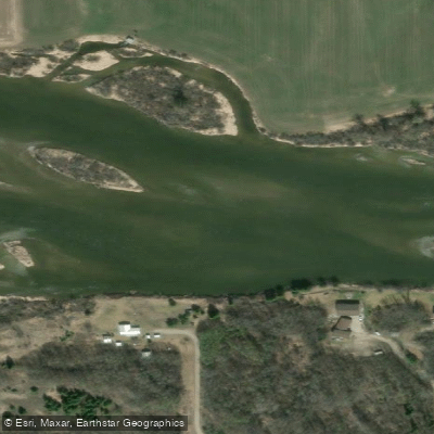
Nechako River
- Boat Ramps
- 6
- Access Points
- 1
- Campsites
- 3
The Nechako River in British Columbia flows generally eastward through the central interior of the province, passing through communities including Fraser Lake, Vanderhoof, and Fort Fraser before joining the Fraser River at Prince George. The river offers paddling trips ranging from a few hours to two or three days depending on put-in and take-out selection, and multiple access points allow paddlers to break the route into shorter segments or combine them into a longer journey.
The upper section of the river, from Cheslatta Falls to Fort Fraser, is described as a rewarding float with several large rapids and boils, and is noted as good wildlife viewing territory. The stretch from Fraser Lake toward Prince George features numerous Class II rapids — fast, exciting water with boulders and ledges — and one significant Class III rapid known as Île Pierre (also spelled Isle Pierre), which is characterized by large hydraulics and demanding S-turns. Paddlers should be prepared to scout or portage this drop. The section of the Nechako upstream of Highway 16 is generally mellower. The river runs through wide-open farmland with occasional views of the highway, meaning paddlers are rarely far from civilization. Carrying a full load of camping gear will reduce maneuverability around boulders and should be factored into planning.
In Vanderhoof, the river is accessible via a boat launch on the southeast side of the bridge, across from Riverside Park. In Prince George, a concrete boat launch at Cottonwood Park provides reliable access for canoes, kayaks, and other watercraft. The Cottonwood Park facility was constructed to replace an inadequate mud-and-gravel launch and supports both recreational and search-and-rescue use.
August is a common paddling month, though at least one paddler noted that water levels can run low by that time of year, which may affect passage through shallower sections. The river corridor offers opportunities for wildlife observation, and the upper reaches in particular are noted for this. A guidebook titled "Canoeing + Kayaking BC's Central Interior," published by the Northwest Brigade Paddling Club, covers this river in detail and is recommended for trip planning.
Water access, boat ramps & amenities
Learn how to get on Nechako River. Uncover great paddling access points, boat ramps, and all the facilities you need for an unforgettable day on the water. Some locations shown may border or include private property. Always check property boundaries and applicable regulations before visiting. PaddleWays's Public & Private Land layer can help you plan your access with confidence.
Paddle smarter with real-time insights
Whether you're en route and conditions shift or you're looking for the best spot based on current flows, we enable you to make informed decisions on the fly.







Bc licenses and regulations
No licenses or regulations available for Bc.
Find Places to Paddle

Over 400,000 Places to Paddle
Every user gets free access to launch points, boat ramps, and public property parcels.


Water and weather conditions (10 day forecast)
See the best times to paddle Nechako River and check the forecast before you go.
NECHAKO RIVER BELOW CHESLATTA FALLS
All Flow Stations
Explore Bc waters
Top paddling waters
No waters available right now.
Popular Cities
Loading popular cities...
Explore near Nechako River
Access points
More in Bc

Smarter Paddling Starts in the App.
Paddleways gives you everything you need to plan smarter, paddle better, and own every trip from first launch to takeout.