Cypress River
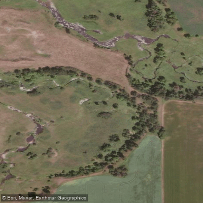
Cypress River
- Boat Ramps
- 0
- Access Points
- 0
- Campsites
- 0
The Cypress River is a prairie river in southern Manitoba, located in the Lorne area near coordinates 49.432392, -98.588459. It flows from the Highway 2 crossing toward the Assiniboine River, running adjacent to Spruce Woods Provincial Park. A boat launch is available at Big Pine Lane.
Like many prairie rivers in Manitoba, the Cypress River is highly dependent on water levels and is not reliably paddleable throughout the season. Spring and periods following significant rainfall are the most viable times to paddle, as the river can rise quickly under those conditions. By later in the summer, water levels often drop to the point where paddling becomes impractical. Water gauges are present on the river, and monitoring gauge readings before a trip is strongly recommended to confirm adequate depth.
When water levels are sufficient, the river carries a fair amount of current, making it well-suited as a one-way downstream trip rather than an out-and-back route. The character of the paddle changes as you move downstream, with the river cutting into an increasingly deep gorge that provides scenic, visually interesting paddling. The corridor is described as very scenic and beautiful overall.
Paddlers should be aware of a significant hazard: barbed wire fences are strung across the river at multiple locations. These require careful attention and the ability to stop or portage safely. This hazard makes the river unsuitable for paddlers who cannot identify and respond to low-clearance obstacles in moving water.
The reference book "Canoeing Manitoba Rivers, Vol. 1 South" by John Buchanan (Rocky Mountain Books, 1997) covers Manitoba rivers in this region and may contain more detailed route information for trip planning purposes.
Water access, boat ramps & amenities
Learn how to get on Cypress River. Uncover great paddling access points, boat ramps, and all the facilities you need for an unforgettable day on the water. Some locations shown may border or include private property. Always check property boundaries and applicable regulations before visiting. PaddleWays's Public & Private Land layer can help you plan your access with confidence.
Paddle smarter with real-time insights
Whether you're en route and conditions shift or you're looking for the best spot based on current flows, we enable you to make informed decisions on the fly.







Mb licenses and regulations
No licenses or regulations available for Mb.
Find Places to Paddle

Over 400,000 Places to Paddle
Every user gets free access to launch points, boat ramps, and public property parcels.


Water and weather conditions (10 day forecast)
See the best times to paddle Cypress River and check the forecast before you go.
CYPRESS RIVER NEAR BRUXELLES

Explore Mb waters
Top paddling waters
No waters available right now.
Popular Cities
Loading popular cities...
Explore near Cypress River
Nearby waters
More in Mb

Smarter Paddling Starts in the App.
Paddleways gives you everything you need to plan smarter, paddle better, and own every trip from first launch to takeout.