Blackstone River
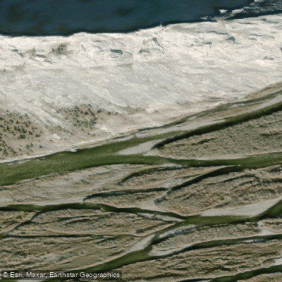
Blackstone River
- Boat Ramps
- 0
- Access Points
- 0
- Campsites
- 0
The Blackstone River is a relatively small, remote waterway in Yukon's Peel Watershed, rated Class I-II whitewater. The river flows east of the Dempster Highway through completely untouched and isolated terrain, covering approximately 140 km before emptying into the Peel River. Despite its modest whitewater rating, the river presents significant practical challenges due to its low volume — even modest rainfall can cause dramatic and rapid water level changes, more so than on many other rivers in the region.
A defining hazard throughout the paddle is the prevalence of woody debris. Strainers and sweepers are common, requiring constant attention. Paddlers are advised to stay on the inside of corners and to follow the channel with the most flow. The river is very low volume, which amplifies the effect of precipitation on conditions.
The typical trip down the Blackstone takes around four to five days of paddling, though parties often extend their time on the river with rest days and hiking. One group completed the paddle in ten days total, including hiking excursions. The surrounding landscape offers opportunities for significant elevation gain hikes, including ascents to ridge tops and peaks such as Mt. Bunoz, with views across the Peel Watershed. Grayling fishing has been noted at certain campsites, particularly near clear tributary streams.
Logistics at the takeout require careful planning. The Blackstone's confluence with the Peel River is remote, and returning to civilization involves one of several options: floatplane extraction, an approximately 10 km overland bushwhack through rough terrain, or lining a boat roughly 50 km up the Ogilvie River — a process that can take around four days. The drive between road access points on the Dempster Highway is approximately 1.5 hours one way.
Very few groups paddle the Blackstone each year, making it a genuinely isolated experience. Insects are a notable factor; bug jackets and repellent are strongly recommended from the outset of the trip. July is a documented paddling season, with trips recorded in mid to late July and into early August. Paddlers should contact local outfitters such as Black Sheep Adventure Sports regarding floatplane pickup logistics and current access conditions.
Water access, boat ramps & amenities
Learn how to get on Blackstone River. Uncover great paddling access points, boat ramps, and all the facilities you need for an unforgettable day on the water. Some locations shown may border or include private property. Always check property boundaries and applicable regulations before visiting. PaddleWays's Public & Private Land layer can help you plan your access with confidence.
Paddle smarter with real-time insights
Whether you're en route and conditions shift or you're looking for the best spot based on current flows, we enable you to make informed decisions on the fly.







Yt licenses and regulations
No licenses or regulations available for Yt.
Find Places to Paddle

Over 400,000 Places to Paddle
Every user gets free access to launch points, boat ramps, and public property parcels.


Water and weather conditions (10 day forecast)
See the best times to paddle Blackstone River and check the forecast before you go.
BLACKSTONE RIVER NEAR CHAPMAN LAKE AIRSTRIP
Explore Yt waters
Top paddling waters
No waters available right now.
Popular Cities
Loading popular cities...
Explore near Blackstone River
Nearby waters
More in Yt

Smarter Paddling Starts in the App.
Paddleways gives you everything you need to plan smarter, paddle better, and own every trip from first launch to takeout.