Río Longaví
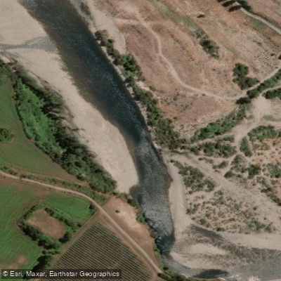
Río Longaví
- Boat Ramps
- 0
- Access Points
- 0
- Campsites
- 0
The Río Longaví is a tributary of the Maule River located in the Province of Linares, Maule Region of Chile. Approximately 120 km long, the river takes its name from the Mapudungun word for "snake's head." Its headwaters originate on the southwestern flank of Nevado de Longaví, a snow-covered extinct volcano reaching 3,230–3,242 m. The upper watershed also includes the Bullileo and Digua dams. From there the river flows generally northwestward, passing near the town of Longaví before joining the Perquilauquén River to form the Loncomilla River.
For paddlers, the Longaví offers a short but worthwhile class 3–4 run with crystal-clear water. The river carries good flow during winter, spring, and early summer, and is best paddled before January. An estimated optimal flow is between 1,000 and 2,000 CFS.
To reach the takeout, follow the Pan American Highway (Ruta 5) to the town of Parral, then drive southeast approximately 25 km. A recommended approach is to head east via the road toward Bullileo to reach the takeout at the hydrological river gauge near San Pablo. From the takeout, continue upstream approximately 6 km to Puente Malcho, which serves as the put-in. Note that the route via Termas de Catillo is longer, requiring a return of roughly 10 km to the north.
The river corridor supports notable biodiversity. The Longaví functions as a significant biological corridor for native species including the pudú and the Chilean fox, among others. The surrounding landscape offers striking natural scenery consistent with the Andean foothills of the Maule Region.
Commercial rafting operations are active on the river, with guided trips of approximately two hours available out of the Parral area. Other rivers in the vicinity include the Ancoa, Achibueno, and Nuble, which may be of interest to paddlers planning a multi-day regional itinerary.
Water access, boat ramps & amenities
Learn how to get on Río Longaví. Uncover great paddling access points, boat ramps, and all the facilities you need for an unforgettable day on the water. Some locations shown may border or include private property. Always check property boundaries and applicable regulations before visiting. PaddleWays's Public & Private Land layer can help you plan your access with confidence.
Paddle smarter with real-time insights
Whether you're en route and conditions shift or you're looking for the best spot based on current flows, we enable you to make informed decisions on the fly.







Maule licenses and regulations
No licenses or regulations available for Maule.
Find Places to Paddle

Over 400,000 Places to Paddle
Every user gets free access to launch points, boat ramps, and public property parcels.


Water and weather conditions (10 day forecast)
See the best times to paddle Río Longaví and check the forecast before you go.
Rio Longavi En La Quiriquina
All Flow Stations
Paddling near Río Longaví
Explore Maule waters
Top paddling waters
No waters available right now.
Popular Cities
Loading popular cities...
Explore near Río Longaví

Smarter Paddling Starts in the App.
Paddleways gives you everything you need to plan smarter, paddle better, and own every trip from first launch to takeout.