Boynton Inlet
- Saltwater
- Inlet
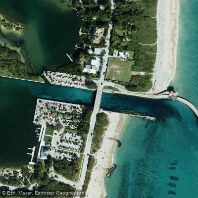
Boynton Inlet
- Saltwater
- Inlet
- Sq. miles
- 0
- Boat Ramps
- 0
- Access Points
- 0
- Campsites
- 3
Boynton Inlet is a coastal inlet connecting the Atlantic Ocean to the Lake Worth Lagoon portion of the Intracoastal Waterway in Palm Beach County, Florida. It is known for being one of the state's more challenging inlets to navigate, especially when ocean conditions are rough, which creates a significant hazard for paddlers. The inlet itself is a focal point for considerable boat traffic, including vessels heading offshore, and paddlers must exercise extreme caution when near its mouth. The adjacent area features several key access points for launching non-motorized craft. Ocean Inlet Park, located on the eastern side of the Intracoastal just south of the inlet, offers a beach launch for canoes and kayaks. Directly across the waterway, Harvey E. Oyer Jr. Park provides a multi-lane boat ramp and a small beach; while busy with powerboats, kayaks are permitted to launch there, often without the trailer fee on weekends. A third option is the tiny beach at Intracoastal Park, just north of Harvey Oyer Park. Paddling routes typically explore the calm waters of the Intracoastal, heading south to nearby waterfront restaurants or north into the broader Lake Worth Lagoon around Hypoluxo Island, where shallow conditions can occur. A popular nearby destination is the shallow sandbar known locally as Beer Can Island, a short paddle from the launch sites but situated close to the active inlet channel. The area is a bird and marine life sanctuary, and wildlife viewing is a common activity. Amenities for paddlers at the parks include parking, restrooms, outdoor showers, and picnic facilities. Due to the narrow sections of the Intracoastal and the high volume of boat traffic, paddling can be turbulent and unpleasant at times. Planning a trip for early morning on weekdays is advised to avoid the busiest periods of both boat and paddler congestion.
Water access, boat ramps & amenities
Learn how to get on Boynton Inlet. Uncover great paddling access points, boat ramps, and all the facilities you need for an unforgettable day on the water. Some locations shown may border or include private property. Always check property boundaries and applicable regulations before visiting. PaddleWays's Public & Private Land layer can help you plan your access with confidence.
Paddle smarter with real-time insights
Whether you're en route and conditions shift or you're looking for the best spot based on current flows, we enable you to make informed decisions on the fly.








Find Places to Paddle

Over 400,000 Places to Paddle
Every user gets free access to launch points, boat ramps, and public property parcels.


Tides, wind & water conditions (10 day forecast)
On open water, wind and tide matter as much as the weather. See the best times to paddle Boynton Inlet and check the marine forecast before you launch.
Loading tide predictions…
Explore Florida waters
Top paddling waters
Popular Cities
Loading popular cities...
Explore near Boynton Inlet
Access points
- Boynton Canal C16 Bridge
- Lwdd C-16 Canal Bridge
- Boynton Canal C-16 Bridge
- Subdivision Canal Bridge
- Lake Ida / Canal E-4 Bridge
- Lwdd E-4 Canal Bridge
- Lwdd E-4 Canal Bridge
- Lwdd E-4 Canal Bridge
- Lake Ida Canal E-4 Bridge
- Palm Beach Traveler Park Campground
- John Prince Park Campground
- Palm Beach County Campground
Nearby waters
More in Florida

Smarter Paddling Starts in the App.
Paddleways gives you everything you need to plan smarter, paddle better, and own every trip from first launch to takeout.