Dry Lake
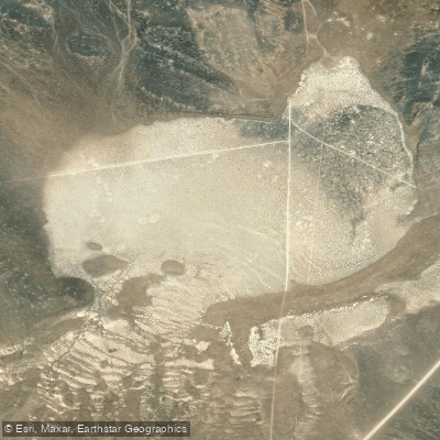
Dry Lake
- Boat Ramps
- 0
- Access Points
- 0
- Campsites
- 0
Dry Lake, located in Clark County, Nevada, presents a unique and ephemeral paddling opportunity that exists only during and after significant precipitation events. This playa lake system sits in the southern portion of Dry Lake Valley, bounded by the Arrow Canyon Range to the west and the Dry Lake Range to the east, at elevations ranging from approximately 1,970 to 2,200 feet. The lake's character is entirely dependent on seasonal rainfall, particularly during Nevada's intense monsoon events or winter storms. During extended dry periods—which is the norm—the lake bed remains completely dry, exposing a flat expanse of playa sediments. However, following major weather events like the historic September 2023 flooding that closed Interstate 15, temporary water bodies can form, creating rare paddling conditions that may last only days to weeks before evaporating.
Access to potential paddling areas requires crossing undeveloped BLM land with numerous dirt roads and trails. Interstate 15 passes through the southeastern portion of the basin, and US Highway 93 runs along portions of the area, providing approach routes. The terrain is characterized by desert scrubland typical of semiarid basins, with minimal vegetation and exposed desert pavement.
When water is present, paddlers should expect extremely shallow conditions with muddy substrates. The water is often turbid from suspended sediments and runoff. Hazards include unpredictable water levels that can change rapidly, soft mud that may trap boats or paddlers attempting to access the water, and the complete absence of facilities or services in this remote location.
The area offers solitude and a chance to experience a rarely-seen desert phenomenon, but requires self-sufficiency, careful timing after precipitation events, and realistic expectations about water quality and depth. Wildlife may include migratory waterfowl taking temporary advantage of the ephemeral wetland conditions.
Water access, boat ramps & amenities
Learn how to get on Dry Lake. Uncover great paddling access points, boat ramps, and all the facilities you need for an unforgettable day on the water. Some locations shown may border or include private property. Always check property boundaries and applicable regulations before visiting. PaddleWays's Public & Private Land layer can help you plan your access with confidence.
Paddle smarter with real-time insights
Whether you're en route and conditions shift or you're looking for the best spot based on current flows, we enable you to make informed decisions on the fly.








Find Places to Paddle

Over 400,000 Places to Paddle
Every user gets free access to launch points, boat ramps, and public property parcels.


Water and weather conditions (10 day forecast)
See the best times to paddle Dry Lake and check the forecast before you go.
No forecast data available.
Explore Nevada waters
Top paddling waters
Popular Cities
Loading popular cities...
Explore near Dry Lake
Nearby waters
More in Nevada

Smarter Paddling Starts in the App.
Paddleways gives you everything you need to plan smarter, paddle better, and own every trip from first launch to takeout.