Snake Indian River
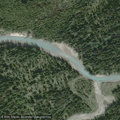
Snake Indian River
- Boat Ramps
- 0
- Access Points
- 0
- Campsites
- 0
The Snake Indian River flows through Jasper National Park in Alberta, Canada, and is divided into two distinct paddling sections by Snake Indian Falls, a waterfall with a drop of approximately 394 feet. This distinction is critical for trip planning, as Parks Canada regulations now prohibit boating on the section above the falls, including the Willow Creek tributary. The section below the falls remains open to paddlers under current regulations. Paddlers should verify the latest Parks Canada rules before planning any trip, as these restrictions were introduced to manage aquatic invasive species and represent a significant change from previous access.
The river is remote and requires a substantial approach. The trail to Snake Indian Falls is approximately 30 kilometers from the trailhead, meaning access to the upper reaches demands either a multi-day backpacking trip or a very long day. The first documented packraft descent of the river above the falls involved hiking in with packrafts, underscoring the expedition-style commitment required. A June trip on the river was described as cold, wet, and snowy, indicating that early-season conditions can be harsh even in summer months.
Parks Canada also requires an Aquatic Invasive Species (AIS) Prevention permit for watercraft used in Jasper National Park. Felt-soled wading boots are banned within the park. Paddlers should stop well in advance of Snake Indian Falls if running any portion of the river above the prohibited zone, as the 394-foot drop presents an extreme and unrunnable hazard.
The river's fishing season runs from March 30 to September 2 and again from November 1 to March 31, which gives some indication of the river's seasonal accessibility, though paddling conditions in early spring and late fall would be demanding given the remote location and mountain environment.
Water access, boat ramps & amenities
Learn how to get on Snake Indian River. Uncover great paddling access points, boat ramps, and all the facilities you need for an unforgettable day on the water. Some locations shown may border or include private property. Always check property boundaries and applicable regulations before visiting. PaddleWays's Public & Private Land layer can help you plan your access with confidence.
Paddle smarter with real-time insights
Whether you're en route and conditions shift or you're looking for the best spot based on current flows, we enable you to make informed decisions on the fly.







Ab licenses and regulations
No licenses or regulations available for Ab.
Find Places to Paddle

Over 400,000 Places to Paddle
Every user gets free access to launch points, boat ramps, and public property parcels.


Water and weather conditions (10 day forecast)
See the best times to paddle Snake Indian River and check the forecast before you go.
No forecast data available.
Explore Ab waters
Top paddling waters
No waters available right now.
Popular Cities
Loading popular cities...
Explore near Snake Indian River

Smarter Paddling Starts in the App.
Paddleways gives you everything you need to plan smarter, paddle better, and own every trip from first launch to takeout.