Shallow Bay
- Saltwater
- Bay
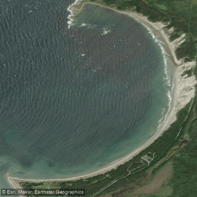
Shallow Bay
- Saltwater
- Bay
- Sq. miles
- 1.3
- Boat Ramps
- 0
- Access Points
- 0
- Campsites
- 0
Shallow Bay is a coastal bay approximately 2.5 kilometers across, extending from Belldowns Point to Lower Head just north of Cow Head within Gros Morne National Park. The bay is bordered by a long, sandy beach, noted to be about 4 km in length, which provides almost continuous and ideal landing areas for paddlers. Primary access points for launching and landing are the Shallow Bay Campground and the Shallow Bay Day Use Area, both of which provide direct beach access. The bay offers partial shelter from the open Gulf of St. Lawrence but is exposed to prevailing westerly winds, which can be strong and are noted to often increase in the afternoon. The shallow nature of the bay is emphasized, with a sandy floor that allows one to walk out a great distance while the water remains below waist depth. This characteristic suggests a generally gentle gradient and minimal surf zone at the beach entry, though wind-driven chop can develop.
The bay provides scenic views of the Long Range Mountains and is known for great sunset vistas. A notable natural feature is the presence of breeding bird colonies on the Belldowns Islands at the south end of the bay; paddlers must respect these areas by not landing on the islands and maintaining distance from the shoreline during breeding season. While the bay itself is a suitable paddling area, the adjacent Gulf of St. Lawrence and outer coastal areas are exposed marine environments where strong westerly winds, large swells, and breaking waves are common, requiring advanced surf skills. A recommended route for experienced paddlers with open ocean experience involves starting from St. Paul's, navigating past Cow Head Peninsula into Cow Cove, and then potentially portaging across a short causeway to enter Cow Head Harbour and Shallow Bay. This route can involve significant swells, submerged rocks near shore, and strong winds, particularly from the southwest. Paddling is permitted, and while no specific water temperature data is provided, the location on the Gulf of St. Lawrence suggests cold water typical of the Newfoundland coast. A permit is required for any backcountry or primitive campsite accessed by water within the national park.
Water access, boat ramps & amenities
Learn how to get on Shallow Bay. Uncover great paddling access points, boat ramps, and all the facilities you need for an unforgettable day on the water. Some locations shown may border or include private property. Always check property boundaries and applicable regulations before visiting. PaddleWays's Public & Private Land layer can help you plan your access with confidence.
Paddle smarter with real-time insights
Whether you're en route and conditions shift or you're looking for the best spot based on current flows, we enable you to make informed decisions on the fly.







Nl licenses and regulations
No licenses or regulations available for Nl.
Find Places to Paddle

Over 400,000 Places to Paddle
Every user gets free access to launch points, boat ramps, and public property parcels.


Tides, wind & water conditions (10 day forecast)
On open water, wind and tide matter as much as the weather. See the best times to paddle Shallow Bay and check the marine forecast before you launch.
Loading tide predictions…
Paddling near Shallow Bay
Explore Nl waters
Top paddling waters
No waters available right now.
Popular Cities
Loading popular cities...
Explore near Shallow Bay

Smarter Paddling Starts in the App.
Paddleways gives you everything you need to plan smarter, paddle better, and own every trip from first launch to takeout.