Buffer Lake
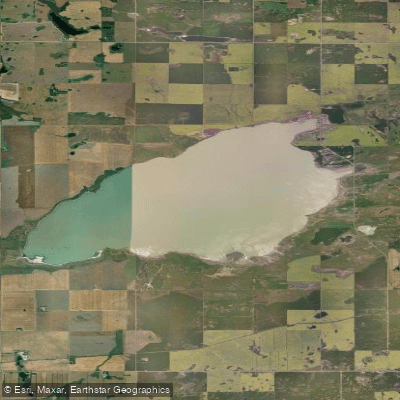
Buffer Lake
- Boat Ramps
- 0
- Access Points
- 0
- Campsites
- 0
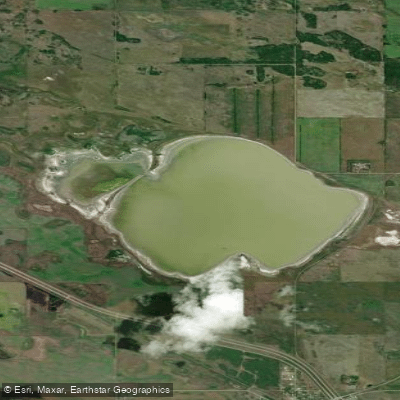
Buffer Lake is a large, shallow salt lake located in the Rural Municipality of Grant No. 372, approximately 5 kilometres northeast of Vonda, Saskatchewan, and about 90 kilometres northeast of Saskatoon. The lake covers a surface area of 2,602 hectares (6,430 acres) with a shoreline of approximately 37 kilometres, sitting at an elevation of 508 metres. It has no primary outflow and is part of the Saskatchewan River drainage basin.
Water levels are largely dependent on spring runoff and seasonal rainfall, which means conditions can vary considerably from year to year. During extended drought periods, extensive mudflats form around the lake's edges, which would significantly affect access and paddling conditions. The lake's salinity is also subject to change during dry periods, as reduced water volume concentrates dissolved minerals. Paddlers should be aware that the surrounding land is almost entirely under private ownership and has been cultivated for agricultural purposes, which limits access options.
The lake holds designation as an Important Bird Area of Canada (IBA SK076), covering 129.72 square kilometres. Five gravelly beaches along the western and northern shores have been designated as critical piping plover habitat under the provincial Wildlife Habitat Protection Act, with the shoreline up to the high water mark protected from development. Paddlers should be mindful of these protected areas, particularly during nesting seasons. The lake is also significant habitat for whooping cranes and serves as an important staging area for shorebirds during migration. Notable species recorded at the lake include red-necked phalarope, Baird's sandpiper, Hudsonian godwit, sanderling, and buff-breasted sandpiper. A single-day count of over 10,000 shorebirds was recorded during spring migration surveys, and counts of 12,000 red-necked phalaropes have been documented during spring migration in the early 1990s.
Given the lake's shallow, saline character, its dependence on precipitation for water levels, and the extensive mudflat formation during dry years, paddlers should verify current water levels before planning a trip. The protected shoreline habitat along the northern and western beaches warrants particular care to avoid disturbing nesting shorebirds.
Water access, boat ramps & amenities
Learn how to get on Buffer Lake. Uncover great paddling access points, boat ramps, and all the facilities you need for an unforgettable day on the water. Some locations shown may border or include private property. Always check property boundaries and applicable regulations before visiting. PaddleWays's Public & Private Land layer can help you plan your access with confidence.
Paddle smarter with real-time insights
Whether you're en route and conditions shift or you're looking for the best spot based on current flows, we enable you to make informed decisions on the fly.








Find Places to Paddle

Over 400,000 Places to Paddle
Every user gets free access to launch points, boat ramps, and public property parcels.


Water and weather conditions (10 day forecast)
See the best times to paddle Buffer Lake and check the forecast before you go.
No forecast data available.
Paddling near Buffer Lake
Explore Sk waters
Top paddling waters
No waters available right now.
Popular Cities
Loading popular cities...
Explore near Buffer Lake

Smarter Paddling Starts in the App.
Paddleways gives you everything you need to plan smarter, paddle better, and own every trip from first launch to takeout.