Comins Lake
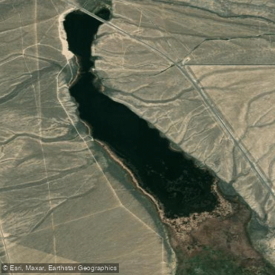
Comins Lake
- Boat Ramps
- 1
- Access Points
- 2
- Campsites
- 1
Comins Lake is a 410-acre reservoir located 7 miles south of Ely, Nevada off Highway 93/50. The lake has a maximum depth of 14-15 feet with an average depth of 8 feet. A primitive boat launch is available on the west side of the reservoir, providing access for paddlers.
The lake sits at 6,550 feet elevation between the Schell Creek and Egan mountain ranges, which create their own weather patterns. Boats must operate at flat wake speeds not exceeding 5 nautical miles per hour. Water levels can fluctuate significantly, dropping 30-40 inches annually due to evapotranspiration despite year-round inflow from Steptoe Creek.
Basic amenities include vault toilets and covered picnic tables along the shoreline. No overnight camping or fires are permitted. The lake typically experiences low congestion levels, offering reasonable solitude even when other visitors are present.
The water has historically experienced periodic quality issues, including brackish coloring from tannins and siltation from Steptoe Creek. The reservoir is fed by Cave and Steptoe Creeks from the east and Willow Creek from the south.
Wildlife viewing opportunities include various waterfowl species. Black-crowned night herons and common loons have been observed on the lake. The surrounding landscape features views of prominent peaks including 10,936-foot Ward Mountain and 10,803-foot North Ward Mountain in the Egan Range.
Spring through fall are the primary seasons for water activities, while the lake's surface typically freezes during winter months. Morning hours often provide calmer conditions before afternoon mountain winds develop.
The reservoir was created in 1953 through the realignment of Highway 93. It is now part of the Steptoe Valley Wildlife Management Area managed by the Nevada Department of Wildlife.
Water access, boat ramps & amenities
Learn how to get on Comins Lake. Uncover great paddling access points, boat ramps, and all the facilities you need for an unforgettable day on the water. Some locations shown may border or include private property. Always check property boundaries and applicable regulations before visiting. PaddleWays's Public & Private Land layer can help you plan your access with confidence.
Paddle smarter with real-time insights
Whether you're en route and conditions shift or you're looking for the best spot based on current flows, we enable you to make informed decisions on the fly.








Find Places to Paddle

Over 400,000 Places to Paddle
Every user gets free access to launch points, boat ramps, and public property parcels.


Water and weather conditions (10 day forecast)
See the best times to paddle Comins Lake and check the forecast before you go.
No forecast data available.
Explore Nevada waters
Top paddling waters
Popular Cities
Loading popular cities...
Explore near Comins Lake
Nearby waters
More in Nevada

Smarter Paddling Starts in the App.
Paddleways gives you everything you need to plan smarter, paddle better, and own every trip from first launch to takeout.