Leigh River
Leigh River
- Boat Ramps
- 0
- Access Points
- 0
- Campsites
- 0
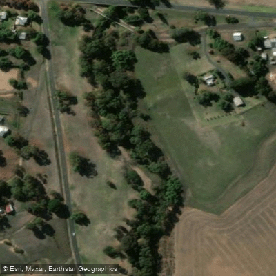
The Leigh River in Victoria flows through the town of Inverleigh, where it meets the Barwon River. This confluence is a notable feature of paddling in the area, with a viewing platform situated at the junction point. The Leigh River enters from the north, while the Barwon continues east toward Geelong.
A practical access point is located at a campsite a couple of hundred metres down the track from the bridge on the Inverleigh-Winchelsea Road, where the bank is flat enough for easy launching. The access track is suitable for 2WD vehicles in dry conditions. From this put-in, paddlers can head downstream to the confluence with the Barwon, or upstream along the Leigh toward the Hamilton Highway bridge — a distance of roughly 1 kilometre. The Hamilton Highway bridge and a rail bridge are both visible along this upstream stretch.
Upstream of the Inverleigh-Winchelsea Road bridge, the river narrows and becomes increasingly obstructed by fallen trees and branches. Despite this, at least 1.5 kilometres of upstream travel has been reported before encountering a log requiring portage or disembarkation. Paddlers should expect to navigate or haul around woody debris in this direction. Shallows beneath the Hamilton Highway bridge may also require dragging a kayak through.
The river has been paddled as recently as November 2024, suggesting year-round accessibility is possible, though water levels will vary seasonally. The surrounding landscape along the Leigh includes a track along the western bank, which provides an alternative perspective on the same corridor for those who have walked the area before paddling it.
Water access, boat ramps & amenities
Learn how to get on Leigh River. Uncover great paddling access points, boat ramps, and all the facilities you need for an unforgettable day on the water. Some locations shown may border or include private property. Always check property boundaries and applicable regulations before visiting. PaddleWays's Public & Private Land layer can help you plan your access with confidence.
Paddle smarter with real-time insights
Whether you're en route and conditions shift or you're looking for the best spot based on current flows, we enable you to make informed decisions on the fly.








Find Places to Paddle

Over 400,000 Places to Paddle
Every user gets free access to launch points, boat ramps, and public property parcels.


Water and weather conditions (10 day forecast)
See the best times to paddle Leigh River and check the forecast before you go.
Leigh River @ Shelford
All Flow Stations
Paddling near Leigh River
Barwon River
Moorabool River

Port Phillip Bay

Werribee River

Port Phillip
Lake Connewarre
Yarra River
Thompson Creek
Woady Yaloak River
Explore Victoria waters
Top paddling waters
No waters available right now.
Popular Cities
Loading popular cities...
Explore near Leigh River

Smarter Paddling Starts in the App.
Paddleways gives you everything you need to plan smarter, paddle better, and own every trip from first launch to takeout.