Werribee River

Werribee River
- Boat Ramps
- 1
- Access Points
- 0
- Campsites
- 3
The Werribee River in Victoria, Australia offers paddling access primarily along its lower reaches, with two well-established launch sites serving as the main entry points. At Riverbend Historical Park, a sign-posted launch is located just off the trail near the car park, which also provides barbecues and picnic tables. From this site, paddlers should head east (right), as the Diversion Weir approximately 300 metres to the west blocks access in that direction with a substantial drop. The eastward route allows for approximately 4 kilometres of paddling before returning to the park.
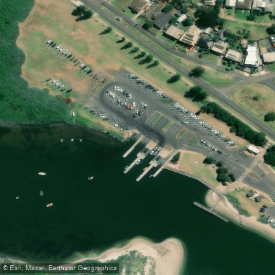
The second launch point is the Werribee South Boat Ramp and Jetty, situated near the mouth of the river along the Werribee South foreshore. Paddlers can launch from the shallow boat ramp on the far right or from the beach areas adjacent to the jetty. From here, options include open-water paddling east toward Wyndham Harbour and Point Cook, or west toward Point Wilson on Port Phillip Bay. Entering the river mouth and paddling upstream is also possible, with a longer route extending approximately 5.5 kilometres to K Road Cliffs and past Werribee Park Golf Club before the route becomes blocked. The cliffs themselves are inaccessible from the water due to their steep sides. The Werribee South Boat Ramp is a free public facility, open 24 hours a day, 365 days a year.
Several hazards warrant attention on the river. Recent rainfall can significantly affect conditions, and paddlers should be alert to submerged rocks and fallen limbs from the River Red Gums lining the banks — paddling in the middle of the river is advised to reduce this risk. The Werribee South foreshore area is heavily used for fishing and boating, so care is needed when launching near the boat ramp. Checking local conditions including weather, recent rainfall, water temperature, currents, wind, and EPA beach reports before heading out is recommended.
The river is noted for its birdlife, making it a worthwhile destination for wildlife observation alongside paddling. The presence of platypus has also been documented in the river through scientific monitoring surveys. The lower river is lined with River Red Gums, giving the waterway a distinctive character. Routes are described as suitable for experienced kayakers and paddlers, particularly the longer upstream stretches from the river mouth.
Water access, boat ramps & amenities
Learn how to get on Werribee River. Uncover great paddling access points, boat ramps, and all the facilities you need for an unforgettable day on the water. Some locations shown may border or include private property. Always check property boundaries and applicable regulations before visiting. PaddleWays's Public & Private Land layer can help you plan your access with confidence.
Paddle smarter with real-time insights
Whether you're en route and conditions shift or you're looking for the best spot based on current flows, we enable you to make informed decisions on the fly.








Find Places to Paddle

Over 400,000 Places to Paddle
Every user gets free access to launch points, boat ramps, and public property parcels.


Water and weather conditions (10 day forecast)
See the best times to paddle Werribee River and check the forecast before you go.
Werribee River @ Bacchus Marsh
All Flow Stations
Paddling near Werribee River
Yarra River
Maribyrnong River

Port Phillip Bay
Kororoit Creek

Port Phillip

Stony Creek
Murrindindi River
St Kilda Beach

Campaspe River
Explore Victoria waters
Top paddling waters
No waters available right now.
Popular Cities
Loading popular cities...
Explore near Werribee River

Smarter Paddling Starts in the App.
Paddleways gives you everything you need to plan smarter, paddle better, and own every trip from first launch to takeout.