Queen Charlotte Channel
- Saltwater
- Channel
Queen Charlotte Channel
- Saltwater
- Channel
- Sq. miles
- 18
- Boat Ramps
- 0
- Access Points
- 0
- Campsites
- 0
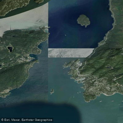
Queen Charlotte Channel is a significant saltwater channel forming the entrance to Howe Sound, located between West Vancouver and Bowen Island. It is a major marine thoroughfare, marking the passage from the Strait of Georgia into the sound. The channel's western boundary is defined by Bowen Island, while its eastern side is lined by the mainland shore of West Vancouver, including prominent points like Whytecliff Park and Point Atkinson. Passage Island sits near the channel's southern entrance, roughly midway between these points. This geography creates a broad, exposed waterway subject to significant wind and current. The steep mainland shores are noted for funneling breezes, and summer days can see winds build to 20 knots or more, generating considerable fetch and chop. This is compounded by heavy vessel traffic, including the regular BC Ferries route between Horseshoe Bay and Nanaimo which passes by Passage Island, as well as potential commercial shipping and tug escorts for projects like the Woodfibre LNG facility. Paddlers must be prepared for strong, unpredictable conditions and maintain constant vigilance for large ships.
Primary access points for paddlers are found on the channel's eastern shore in West Vancouver. Whytecliff Park is a noted launch site, located near Horseshoe Bay. It offers facilities including a parking area and has historically had a concession. The park is also Canada's first Marine Protected Area, home to over 200 marine animal species, with sea lions often seen on the beach in summer. Dorman Point on Bowen Island provides a lookout with views across the channel to Whytecliff Park, Passage Island, and beyond to Vancouver Island on clear days, but does not are a common launch site itself. Paddling here is a year-round possibility as the waters never freeze, but the exposed nature of the channel demands careful planning around tides, weather, and traffic. The area falls under several fishing subareas with specific conservation closures, including Rockfish Conservation Areas and Glass Sponge Reef protections in Howe Sound-Queen Charlotte Channel zones, which paddlers should be aware of to avoid restricted areas.
Water access, boat ramps & amenities
Learn how to get on Queen Charlotte Channel. Uncover great paddling access points, boat ramps, and all the facilities you need for an unforgettable day on the water. Some locations shown may border or include private property. Always check property boundaries and applicable regulations before visiting. PaddleWays's Public & Private Land layer can help you plan your access with confidence.
Paddle smarter with real-time insights
Whether you're en route and conditions shift or you're looking for the best spot based on current flows, we enable you to make informed decisions on the fly.







Bc licenses and regulations
No licenses or regulations available for Bc.
Find Places to Paddle

Over 400,000 Places to Paddle
Every user gets free access to launch points, boat ramps, and public property parcels.


Tides, wind & water conditions (10 day forecast)
On open water, wind and tide matter as much as the weather. See the best times to paddle Queen Charlotte Channel and check the marine forecast before you launch.
Loading tide predictions…
Paddling near Queen Charlotte Channel

Fleuve Fraser
Capilano River

Burrard Inlet

Lynn Creek

Coquitlam River
Outer Vancouver Harbour

Pitt River

Serpentine River
Inner Vancouver Harbour

Alouette River
Explore Bc waters
Top paddling waters
No waters available right now.
Popular Cities
Loading popular cities...
Explore near Queen Charlotte Channel

Smarter Paddling Starts in the App.
Paddleways gives you everything you need to plan smarter, paddle better, and own every trip from first launch to takeout.