Tuxedni Bay
- Saltwater
- Bay
Tuxedni Bay
- Saltwater
- Bay
- Sq. miles
- 38
- Boat Ramps
- 0
- Access Points
- 0
- Campsites
- 0
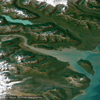
Tuxedni Bay is a large, remote coastal bay on the west side of Cook Inlet within Lake Clark National Park. It is a glacially silted estuary covering approximately seven square miles, flanked by the Chigmit Mountains. Access is exclusively by air, with wheeled airplanes landing on the beach or floatplanes dropping paddlers near the shore from Homer or Anchorage. There are no traditional road-accessible launches or public facilities. The bay experiences strong tidal currents, and its waters are glacially silted. The coastline features a mix of beaches, grassy meadows, and cliffs. This area is a designated critical habitat, known for a high concentration of brown bears that gather on the sedge grasses from mid-May through mid-July. Other wildlife includes harbor seals on sand bars and significant bird rookeries hosting pelagic seabirds like puffins and kittiwakes. Points of interest for paddlers include an ancient Jurassic-period fossil bed, a historic salmon cannery from 1917, a serene isolated island, and a cave displaying early Native American petroglyphs. The overall experience is one of profound wilderness with very little human traffic compared to nearby areas. Paddling here requires complete self-sufficiency and careful planning for remote, bear-country conditions.
Water access, boat ramps & amenities
Learn how to get on Tuxedni Bay. Uncover great paddling access points, boat ramps, and all the facilities you need for an unforgettable day on the water. Some locations shown may border or include private property. Always check property boundaries and applicable regulations before visiting. PaddleWays's Public & Private Land layer can help you plan your access with confidence.
Paddle smarter with real-time insights
Whether you're en route and conditions shift or you're looking for the best spot based on current flows, we enable you to make informed decisions on the fly.








Find Places to Paddle

Over 400,000 Places to Paddle
Every user gets free access to launch points, boat ramps, and public property parcels.


Tides, wind & water conditions (10 day forecast)
On open water, wind and tide matter as much as the weather. See the best times to paddle Tuxedni Bay and check the marine forecast before you launch.
Loading tide predictions…
Explore Alaska waters
Top paddling waters
Popular Cities
Loading popular cities...
Explore near Tuxedni Bay
More in Alaska

Smarter Paddling Starts in the App.
Paddleways gives you everything you need to plan smarter, paddle better, and own every trip from first launch to takeout.