Curated by PaddleWays

West Branch Penobscot River

13.3 mi whitewater route on the West Branch Penobscot River in Maine


Map of the West Branch Penobscot River route, from Penobscot, Rip Gorge Put-in to WB Penobscot River Boat Ramp
  • Route
  • Put-in
  • Take-out
  • Hazards

Level right now

How West Branch Penobscot River is running today

Recommended level from the route description.

Route facts

West Branch Penobscot River at a glance

Distance
13.3 mi
Paddle time
Multi-day
Type
Whitewater · Class V
Recommended level
1,000–4,000 cfsfrom the route description
Best in
Summer
Good for
Experienced paddlers

Solid class IV and a bit of class V whitewater

About this route

Paddling West Branch Penobscot River

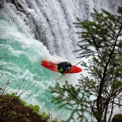
The Rip Gorge section of the Penobscot offers a remote Maine wilderness experience with solid class IV and a bit of class V whitewater with dependable flows all summer long. With camping nearby, as well as Mt Katahdin, the terminus of the Appalachian trail, it’s a great section to make a weekend out of. If the difficulty of the whitewater intimidates you, there is a lower section that’s class III-IV. Good flows out here would be 1000cfs on the low end to around 4000cfs on the high end. 

© Lynnemariehale|Dreamstime.com


Put-in and take-out

Hazards

Hazards on West Branch Penobscot River

No paddler has reported a hazard here yet, so these are the dams, falls and big rapids on our map. Hazards change with flows and storms, so check them before you launch.

  1. Abol Falls

    From our map

    Waterfall

    We have no details on this waterfall.

  2. Waterfall

    We have no details on this waterfall.

  3. Big Eddy

    From our map

    Waterfall

    We have no details on this waterfall.

  4. Cribworks, The

    From our map

    Waterfall

    We have no details on this waterfall.

  5. Waterfall

    We have no details on this waterfall.

  6. Waterfall

    We have no details on this waterfall.

  7. Pockwockamus Falls

    From our map

    Waterfall

    We have no details on this waterfall.

From the community

West Branch Penobscot River trip reports

Real trips from PaddleWays paddlers who ran this route: how the flows were, and what to watch for.

Loading trip reports

  • Stephen L.

    Kayak •

    Made the drive up to Maine for this one. Totally worth it - Rip Gorge is incredible. Big water, continuous action. Camping at the gorge was perfect.

    Mentions: rapid

Flows & weather (10 day forecast)

The gauges near West Branch Penobscot River and the forecast where it starts, so you can pick your day.

No forecast data available.

Same water

More routes on the West Branch Penobscot River

The other curated routes on the West Branch Penobscot River, each with how it is running now.

Curated by PaddleWays

RouteClass III–V

Distance
2.7 mi
Paddle time
~0.5 hrs
Best for
Experienced paddlers
Put-in → take-out
Seboomook Access → W.B. Penobscot River Boat Ramp
Curated by PaddleWays

RouteClass III–IV

Distance
8.8 mi
Paddle time
~2 hrs
Best for
Experienced paddlers
Put-in → take-out
Quakish Lake Boat Ramp → Dolby Pond Boat Ramp
Curated by PaddleWays

RouteClass III–V

Distance
13.5 mi
Paddle time
~3.5 hrs
Best for
Experienced paddlers
Put-in → take-out
Penobscot, Rip Gorge Put-in → WB Penobscot River Boat Ramp
Intense Class V rapids through Ripogenus Gorge
Curated by PaddleWays

RouteFlatwater

Distance
16.5 mi
Paddle time
3–4 days
Best for
Canoe
Put-in → take-out
Lobster Stream Boat Ramp → Pine Stream Access
Curated by PaddleWays

RouteClass I–III

Distance
43.9 mi
Paddle time
4–5 days
Put-in → take-out
W.B. Penobscot River Boat Ramp → Chesuncook Lake Boat Ramp
Class II-III ledge drops at Old Roll Dam

Close by

Routes near West Branch Penobscot River

Curated routes on other waters within an hour or so, nearest first.

Curated by PaddleWays

RouteClass II–III

Distance
7.4 mi
Paddle time
~2 hrs
Best for
Intermediate paddlers
Put-in → take-out
First Roach Pond Boat Ramp → Moosehead Lake Boat Ramp
Curated by PaddleWays

RouteClass II–III

Distance
15.4 mi
Paddle time
~4 hrs
Best for
Canoe
Put-in → take-out
Lunksoos Boat Ramp → Grindstone Falls Access
Four waterfalls requiring portages
Curated by PaddleWays

RouteClass II–III

Distance
20.2 mi
Paddle time
4–7 hrs
Put-in → take-out
Grand Pitch Trail Hand Launch → Lunksoos Boat Ramp
Challenging rapid at the end

Smarter Paddling Starts in the App.

PaddleWays gives you everything you need to plan smarter, paddle better, and own every trip from first launch to takeout.
