Hell Gate
- Saltwater
- Sea area
Hell Gate
- Saltwater
- Sea area
- Sq. miles
- 0.4
- Boat Ramps
- 0
- Access Points
- 0
- Campsites
- 0
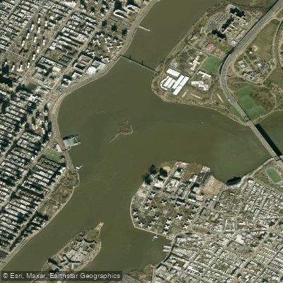
Hell Gate is a notoriously challenging tidal strait within New York City's East River, located on the east side of Randall's Island between Astoria, Queens and Mill Rock. It is a critical and complex segment for paddlers undertaking the classic 30-mile circumnavigation of Manhattan. The primary consideration is its powerful, predictable tidal currents, which can exceed 5 knots during peak ebb and flood. For a counter-clockwise Manhattan circumnavigation, paddlers must time their arrival at Hell Gate at or before the turn from flood to ebb tide to ride the flood current up the East River and then the ebb up the Harlem River. Missing this timing means facing a contrary current faster than most can paddle. If caught against a building ebb, a known strategy is to hug the Queens shoreline from the Roosevelt Island Bridge northward, using the crumbling seawall and outcroppings to find eddies and block the current's force, though this requires careful maneuvering around submerged debris. The water under the historic Hell Gate Bridge is known for disconcerting whirlpools during strong currents; the technique is to paddle hard to maintain momentum and stability. The area is exposed to wind and features significant commercial and recreational boat traffic, including tugs, barges, ferries, and water taxis. There are no sandy beaches for landing, and rescue options are limited. It is emphatically not a beginner area and should only be attempted with experienced guides or groups familiar with New York Harbor dynamics. Key access points for trips involving Hell Gate are not detailed, but successful transit is typically part of a larger route launching from locations like Pier 40 on the Hudson River. The aesthetic is intensely urban, passing under major bridges and past landmarks like the Rikers Island prison barge, with the Brother Islands visible but off-limits for landing. Planning requires consulting detailed current predictions from resources like the Eldridge Tide and Pilot Book or the Stevens Institute model, with Hell Gate itself being a key reference point for timing currents throughout the upper East River.
Water access, boat ramps & amenities
Learn how to get on Hell Gate. Uncover great paddling access points, boat ramps, and all the facilities you need for an unforgettable day on the water. Some locations shown may border or include private property. Always check property boundaries and applicable regulations before visiting. PaddleWays's Public & Private Land layer can help you plan your access with confidence.
Paddle smarter with real-time insights
Whether you're en route and conditions shift or you're looking for the best spot based on current flows, we enable you to make informed decisions on the fly.








Find Places to Paddle

Over 400,000 Places to Paddle
Every user gets free access to launch points, boat ramps, and public property parcels.


Tides, wind & water conditions (10 day forecast)
On open water, wind and tide matter as much as the weather. See the best times to paddle Hell Gate and check the marine forecast before you launch.
Loading tide predictions…
Paddling near Hell Gate

Hudson River
Lake Hopatcong
Jamaica Bay
Rockaway River

Raritan River
Flushing Bay

Croton River
Swartswood Lake
Spruce Run Reservoir
Explore New York waters
Top paddling waters
Popular Cities
Loading popular cities...
Explore near Hell Gate
Access points
- Rfk Bridge To Harlem Riv Bridge
- Bronx Kills Csx Harlem Bridge
- Rte 907p Rte 907p Madi Bridge
- Long Island Rr Bridge
- Lirr Newtown Creek Bridge
- Nycta Irt Subway Harlem Bridge
- Rte 907p Rte 907p Rte Bridge
- Csx / Amtrak Rr Bridge
- Newtown Creek Bridge
- Rte I95 95i X North Fro Bridge
- Nj 5 & Wolf Creek Bridge
- Wolf Creek Bridge
- All 17 spots
Nearby waters
More in New York

Smarter Paddling Starts in the App.
Paddleways gives you everything you need to plan smarter, paddle better, and own every trip from first launch to takeout.