Hardy Inlet
- Saltwater
- Estuary
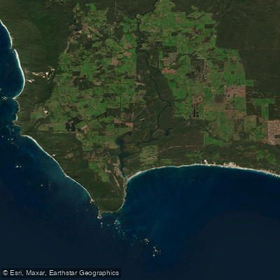
Hardy Inlet
- Saltwater
- Estuary
- Sq. miles
- 8.7
- Boat Ramps
- 0
- Access Points
- 0
- Campsites
- 0
Hardy Inlet is a wave-dominated estuary located at the southern tip of Western Australia, where the Blackwood and Scott rivers converge before meeting the Southern Ocean via Flinders Bay. The inlet has a total surface area of 20 square kilometres, characterized by a wide basin with predominantly shallow banks less than one metre deep, intersected by deeper channels ranging from two to eight metres. The entrance channel to the ocean is long, narrow, and known to shift. The town of Augusta sits on the inlet's southwestern shore, providing convenient access. Primary launch and take-out points for paddlers include the foreshore near Turners Caravan Park and the Colourpatch Cafe, where water quality is monitored. The Augusta Boat Harbour within Flinders Bay is another access point, though paddlers should be aware of boat traffic from whale-watching and other charters departing there. The inland waters of the inlet are generally calm and peaceful, contrasting with the open ocean beyond, making it suitable for kayaking and stand-up paddleboarding. Paddling is best during the warmer months from November to March, which also coincides with the arrival of migratory wading birds along the shores. The tidal nature of the estuary means paddlers must plan around the tides, particularly when navigating the shallow banks and the shifting entrance channel. Water skiing and wakeboarding occur in designated areas, so paddlers should remain vigilant for powered boat traffic. Wildlife sightings are a key feature, with pelicans, eagle rays, stingrays, Australasian darters, Caspian terns, and the possibility of seeing whales in the broader bay during their migration from June to September. Algal blooms have occurred in areas like Molloy Island and West Bay, leading to health advisories; paddlers should avoid swallowing water, heed any posted warning signs, and not consume shellfish from the inlet. The foreshore features a boardwalk and paths ideal for scenic walks before or after a paddle.
Water access, boat ramps & amenities
Learn how to get on Hardy Inlet. Uncover great paddling access points, boat ramps, and all the facilities you need for an unforgettable day on the water. Some locations shown may border or include private property. Always check property boundaries and applicable regulations before visiting. PaddleWays's Public & Private Land layer can help you plan your access with confidence.
Paddle smarter with real-time insights
Whether you're en route and conditions shift or you're looking for the best spot based on current flows, we enable you to make informed decisions on the fly.







Western Australia licenses and regulations

Find Places to Paddle

Over 400,000 Places to Paddle
Every user gets free access to launch points, boat ramps, and public property parcels.


Tides, wind & water conditions (10 day forecast)
On open water, wind and tide matter as much as the weather. See the best times to paddle Hardy Inlet and check the marine forecast before you launch.
Loading tide predictions…
Paddling near Hardy Inlet
Preston River
Margaret River
Tobys Inlet
Blackwood River
Collie River
Abbey Beach
Capel River
Donnelly River
Eagle Bay
Brunswick River
Explore Western Australia waters
Top paddling waters
No waters available right now.
Popular Cities
Loading popular cities...
Explore near Hardy Inlet
Nearby waters
More in Western Australia

Smarter Paddling Starts in the App.
Paddleways gives you everything you need to plan smarter, paddle better, and own every trip from first launch to takeout.