Moses Rock North
- Saltwater
- Beach
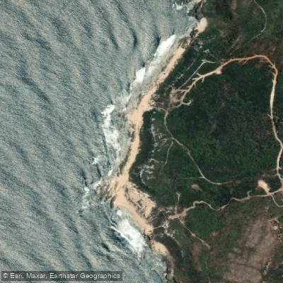
Moses Rock North
- Saltwater
- Beach
- Sq. miles
- 0.1
- Boat Ramps
- 0
- Access Points
- 0
- Campsites
- 0
Moses Rock North is a coastal beach access point located within the City of Busselton in Western Australia. The primary facilities for paddlers include a gravel road leading to a carpark and a public toilet. The beach serves as a key point along the famous Cape to Cape Track, a long-distance coastal walking trail, indicating its integration into a region of significant natural beauty. The immediate area is characterized by coastal heath and limestone cliffs typical of the Leeuwin-Naturaliste region. Paddlers launching from Moses Rock North will find themselves on the Indian Ocean, with the coastline offering a mix of rocky headlands and sandy beaches. The track between Moses Rock North and nearby Quininup Falls suggests that inland natural features like waterfalls are accessible from this coastal starting point, potentially offering a combined land-and-water excursion for those carrying lightweight craft. The broader area is known for its wineries and other coastal attractions like Injidup Beach and Canal Rocks, which are logical paddling destinations for experienced kayakers or stand-up paddleboarders venturing along the coast. Given its exposure to the open ocean, conditions here are heavily influenced by Southern Ocean swells and prevailing winds, making it suitable primarily for experienced paddlers comfortable with surf launches and landings. The best seasons for paddling typically align with the calmer summer months, though local wind patterns should always be checked. As a beach within a natural area, general regulations protecting the coastal environment apply.
Water access, boat ramps & amenities
Learn how to get on Moses Rock North. Uncover great paddling access points, boat ramps, and all the facilities you need for an unforgettable day on the water. Some locations shown may border or include private property. Always check property boundaries and applicable regulations before visiting. PaddleWays's Public & Private Land layer can help you plan your access with confidence.
Paddle smarter with real-time insights
Whether you're en route and conditions shift or you're looking for the best spot based on current flows, we enable you to make informed decisions on the fly.







Western Australia licenses and regulations

Find Places to Paddle

Over 400,000 Places to Paddle
Every user gets free access to launch points, boat ramps, and public property parcels.


Tides, wind & water conditions (10 day forecast)
On open water, wind and tide matter as much as the weather. See the best times to paddle Moses Rock North and check the marine forecast before you launch.
Loading tide predictions…
Paddling near Moses Rock North
Preston River
Margaret River
Tobys Inlet
Blackwood River
Collie River
Abbey Beach
Capel River
Donnelly River
Eagle Bay
Brunswick River
Explore Western Australia waters
Top paddling waters
No waters available right now.
Popular Cities
Loading popular cities...
Explore near Moses Rock North
Nearby waters
More in Western Australia

Smarter Paddling Starts in the App.
Paddleways gives you everything you need to plan smarter, paddle better, and own every trip from first launch to takeout.