Castle River
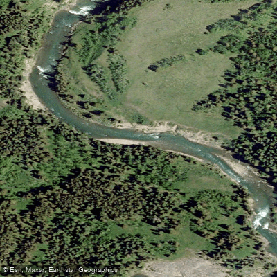
Castle River
- Boat Ramps
- 0
- Access Points
- 0
- Campsites
- 0
The Castle River in Alberta's Municipal District of Pincher Creek and Castle Provincial Park offers several distinct paddling reaches, ranging from technical whitewater to mellow float trips. The river is fed by Rocky Mountain snowmelt, making May through early summer the primary paddling season, with flows also responding noticeably to rainfall events throughout the season. The Water Survey of Canada gauge station 05AA022, Castle River near Beaver Mines, serves as the standard flow reference for trip planning.
The uppermost commonly paddled segment runs from Castle Falls down to Highway 507, beginning with a slide at the falls followed by three significant drops on the reach to the Carbondale River confluence. This stretch is considered one of the best whitewater runs in southern Alberta and is the most frequently paddled segment in the park area. A notable hazard on this reach is an S-bend rapid just below Kirk's cabin on the flatter lower portion toward Highway 507.
The Castle Canyon reach puts in at the Canyon Bridge on Highway 507, locally called the Blue Bridge, and takes out at the Old Gravel Pit downstream. The canyon itself involves bedrock ledges in a tight, committing canyon environment rated Class III. Scouting from the bank before committing is standard practice, particularly at unfamiliar flows. Below the canyon exit, the river continues through additional drops with surfing waves and eddies on both sides of the channel, making these lower features a meaningful part of the day rather than a simple run-out.
The Lower Castle reach begins at the Old Gravel Pit, which doubles as the take-out for the canyon run, and continues to the Old Highway near the Pincher Creek airport. This stretch is rated Class I to Class II, defined by a sequence of sandstone ledges that produce small surfing waves at moderate flows and can become more hydraulic at high water. It is suited to intermediate paddlers seeking play water without technical commitment.
A shorter, easier run operates between the Rodeo Grounds campground and the canyon, rated Class II, with teaching eddies below the campground and larger waves and a drop at the last corner above the bridge. The Oldman Dam Provincial Recreation Area downstream provides a boat launch, hand launch, pit toilets, and access for canoeing and kayaking.
Water access, boat ramps & amenities
Learn how to get on Castle River. Uncover great paddling access points, boat ramps, and all the facilities you need for an unforgettable day on the water. Some locations shown may border or include private property. Always check property boundaries and applicable regulations before visiting. PaddleWays's Public & Private Land layer can help you plan your access with confidence.
Paddle smarter with real-time insights
Whether you're en route and conditions shift or you're looking for the best spot based on current flows, we enable you to make informed decisions on the fly.







Ab licenses and regulations
No licenses or regulations available for Ab.
Find Places to Paddle

Over 400,000 Places to Paddle
Every user gets free access to launch points, boat ramps, and public property parcels.


Water and weather conditions (10 day forecast)
See the best times to paddle Castle River and check the forecast before you go.
CASTLE RIVER NEAR BEAVER MINES
All Flow Stations
Explore Ab waters
Top paddling waters
No waters available right now.
Popular Cities
Loading popular cities...
Explore near Castle River

Smarter Paddling Starts in the App.
Paddleways gives you everything you need to plan smarter, paddle better, and own every trip from first launch to takeout.