Indian Arm
- Saltwater
- Bay
Indian Arm
- Saltwater
- Bay
- Sq. miles
- 11
- Boat Ramps
- 0
- Access Points
- 0
- Campsites
- 0
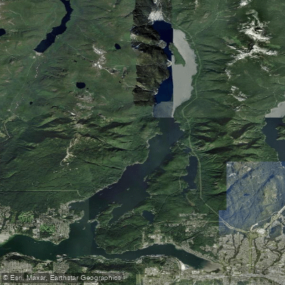
Indian Arm is an 18-kilometer-long, steep-sided fjord extending north from Burrard Inlet in Metro Vancouver. The primary and most popular launch point for paddlers is Deep Cove, a seaside village in North Vancouver. This location offers calm, protected waters within the inner cove, ideal for beginners, though parking can be a significant challenge during peak seasons. Other potential access points include Lowry Waterfront Park and Cates Park. The fjord's character is defined by its dramatic, forested cliffs and limited public shoreline, with many beaches being privately owned. Notable public landing spots include Thwaytes Landing, a water-access-only regional park midway up the arm that provides a rare public beach and access to Holmden Creek Falls, and Granite Falls near the northern terminus, which features a 150-foot waterfall and is considered the best camping area on Indian Arm. Camping is permitted south of Granite Falls and on Twin Islands, with facilities limited to an outhouse and dock at Granite Falls; no fires are allowed at any campsites or islands.
Paddling hazards are significant and require careful planning. Motorboat traffic is present throughout the fjord. Afternoon warming on sunny days frequently creates strong headwinds, particularly for southbound return trips to Deep Cove, which can make the journey back substantially longer than the outbound paddle. The outflow currents from the Indian River estuary near Granite Falls can also be felt. Tidal currents are a factor. The recommended route to Granite Falls from Deep Cove follows the west shore to Croker Island, taking the west channel between the island and the mainland, a distance of 18 kilometers requiring three to six hours of paddling one way depending on pace and conditions. Wildlife encounters, including bears, have been reported in the area. The water is saltwater, being a coastal fjord, and its cleanliness is not specifically detailed. The area holds cultural significance, as it is also known as Səl̓ilw̓ət and Say Nuth Khaw Yum Park.
Water access, boat ramps & amenities
Learn how to get on Indian Arm. Uncover great paddling access points, boat ramps, and all the facilities you need for an unforgettable day on the water. Some locations shown may border or include private property. Always check property boundaries and applicable regulations before visiting. PaddleWays's Public & Private Land layer can help you plan your access with confidence.
Paddle smarter with real-time insights
Whether you're en route and conditions shift or you're looking for the best spot based on current flows, we enable you to make informed decisions on the fly.







Bc licenses and regulations
No licenses or regulations available for Bc.
Find Places to Paddle

Over 400,000 Places to Paddle
Every user gets free access to launch points, boat ramps, and public property parcels.


Tides, wind & water conditions (10 day forecast)
On open water, wind and tide matter as much as the weather. See the best times to paddle Indian Arm and check the marine forecast before you launch.
Loading tide predictions…







Explore Bc waters
Top paddling waters
No waters available right now.
Popular Cities
Loading popular cities...
Explore near Indian Arm

Smarter Paddling Starts in the App.
Paddleways gives you everything you need to plan smarter, paddle better, and own every trip from first launch to takeout.