Mount Carmel Pond
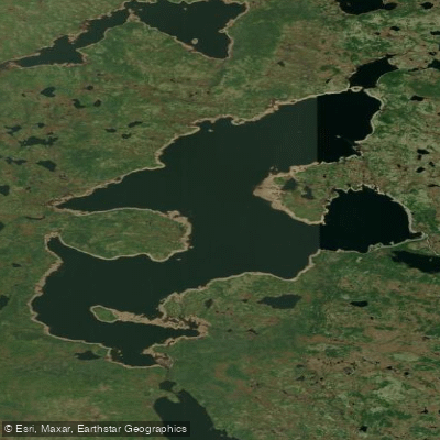
Mount Carmel Pond
- Boat Ramps
- 0
- Access Points
- 0
- Campsites
- 0
Mount Carmel Pond sits within the Avalon Wilderness Reserve on the Avalon Peninsula of Newfoundland and Labrador, serving as one of the primary put-in points for multi-day paddling expeditions through the reserve. The pond is notably large — described by one experienced paddler as a "monstrosity" — and forms the starting point of a roughly 45-kilometre paddling route westward to Peak Pond, making it slightly longer than the comparable Cape Pond route, which covers just over 40 kilometres to the same destination.
Access to the pond is via Horse Chops Road, located in Cape Broyle on the southern shore. This road is rough and demanding; a truck or high-clearance vehicle is strongly recommended, as standard passenger vehicles risk undercarriage damage on the approach. The east end of the pond is referenced in the Avalon Wilderness Reserve Order as a boundary point, suggesting the access road reaches that end of the water body.
From Mount Carmel Pond, paddlers typically head west across the pond and then portage over a marsh into Middle Pond before continuing downstream into Cape Pond. The river connecting these water bodies is rocky and often requires lining boats rather than paddling. The full route to Peak Pond covers approximately 45 kilometres and is commonly done as a multi-day trip. The pond has also been used as the starting point for raft trips, indicating it accommodates a range of watercraft.
Wind can be a factor on the open water of the pond itself, as paddlers have noted heading into the wind when crossing toward the west side. The surrounding landscape is consistent with the broader Avalon Wilderness Reserve — a remote, roadless interior with wetlands, rivers, and interconnected ponds. Wildlife and wilderness character are central to the experience, given the reserve's protected status under the Wilderness and Ecological Reserves Act.
Because Mount Carmel Pond lies within the Avalon Wilderness Reserve, paddlers should consult the reserve's regulations before planning a trip, as rules governing access and activities within the reserve may apply.
Water access, boat ramps & amenities
Learn how to get on Mount Carmel Pond. Uncover great paddling access points, boat ramps, and all the facilities you need for an unforgettable day on the water. Some locations shown may border or include private property. Always check property boundaries and applicable regulations before visiting. PaddleWays's Public & Private Land layer can help you plan your access with confidence.
Paddle smarter with real-time insights
Whether you're en route and conditions shift or you're looking for the best spot based on current flows, we enable you to make informed decisions on the fly.







Nl licenses and regulations
No licenses or regulations available for Nl.
Find Places to Paddle

Over 400,000 Places to Paddle
Every user gets free access to launch points, boat ramps, and public property parcels.


Water and weather conditions (10 day forecast)
See the best times to paddle Mount Carmel Pond and check the forecast before you go.
No forecast data available.
Paddling near Mount Carmel Pond
Explore Nl waters
Top paddling waters
No waters available right now.
Popular Cities
Loading popular cities...
Explore near Mount Carmel Pond

Smarter Paddling Starts in the App.
Paddleways gives you everything you need to plan smarter, paddle better, and own every trip from first launch to takeout.