Stave River
Stave River
- Boat Ramps
- 0
- Access Points
- 0
- Campsites
- 0
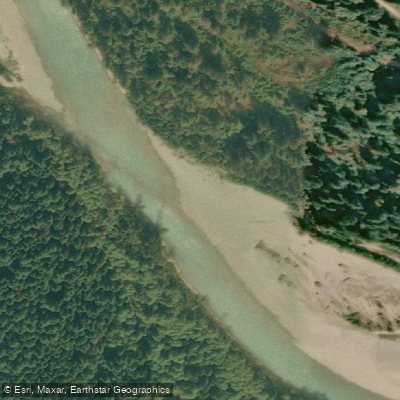
The Stave River drains Coast Mountain snowmelt from Garibaldi Park southward to the Fraser River in southwest British Columbia. It occupies a distinct drainage corridor flanked by rivers flowing west into Howe Sound and the Squamish River system, and by the extensive Lillooet River and Harrison Lake drainage on other sides. The upper watershed lies within Garibaldi Park, which has kept roads out of the upper valley entirely; the moment the river crosses the park boundary, a road runs alongside it and the valley shows heavy clear-cutting. This contrast defines the character of the trip: remote and wild in the upper reaches, more accessible below.
Access to the upper put-in is by floatplane only. Historically, flights have departed from Whistler to a small lake below the Stave Glacier, though paddlers should verify current floatplane availability before planning. There is no road access to the upper valley. The river is rated Class V, with sections reaching V+ to VI, making it suitable only for highly experienced whitewater kayakers.
The upper section begins with several kilometers of splashy, easier whitewater down to a trifluence where two tributaries enter — one on river left, one on river right. Below this confluence, the character changes with the first canyon, which should be scouted carefully. A gravel bar just upstream of the first canyon provides a logical campsite. The trip is typically run over three days, with hard portaging required in addition to the serious whitewater. There is described potential for significant unrun lines in the river, indicating that some sections remain exploratory in nature.
The overall experience is a committing multi-day wilderness expedition with little record of prior travel. The upper corridor is rugged mountain terrain with no road access, meaning self-rescue and evacuation are extremely difficult. Paddlers should be prepared for all contingencies in a remote environment.
Below the upper river, the Stave is dammed at Ruskin Dam, and the lower river below the dam is a separate paddling and fishing environment. Water conditions below the dam tend to be more stable, as the dam moderates the effects of rainfall and runoff on water clarity and flow.
Water access, boat ramps & amenities
Learn how to get on Stave River. Uncover great paddling access points, boat ramps, and all the facilities you need for an unforgettable day on the water. Some locations shown may border or include private property. Always check property boundaries and applicable regulations before visiting. PaddleWays's Public & Private Land layer can help you plan your access with confidence.
Paddle smarter with real-time insights
Whether you're en route and conditions shift or you're looking for the best spot based on current flows, we enable you to make informed decisions on the fly.







Bc licenses and regulations
No licenses or regulations available for Bc.
Find Places to Paddle

Over 400,000 Places to Paddle
Every user gets free access to launch points, boat ramps, and public property parcels.


Water and weather conditions (10 day forecast)
See the best times to paddle Stave River and check the forecast before you go.
STAVE RIVER ABOVE STAVE LAKE
Paddling near Stave River







Explore Bc waters
Top paddling waters
No waters available right now.
Popular Cities
Loading popular cities...
Explore near Stave River

Smarter Paddling Starts in the App.
Paddleways gives you everything you need to plan smarter, paddle better, and own every trip from first launch to takeout.