Curated by PaddleWays
RouteFlatwater
- Distance
- 6.1 mi
- Paddle time
- ~2 hrs
- Put-in → take-out
- Grist Mill Road Boat Ramp → Childersburg Boat Ramp
Talladega Creek flows through east-central Alabama, offering paddlers a genuine backcountry creek experience in a region better known for its national forest lands and covered bridge heritage. The creek system provides limited but worthwhile paddling opportunities for those seeking less-traveled waterways in the Talladega area.
The primary documented paddling section runs from Skyway Motorway to Waldo Bridge on State Route 77, delivering a decent-length run that stands out as one of the few quality paddling stretches within this creek system. This section passes near the historic town of Waldo, located approximately six miles southeast of Talladega, where paddlers can find the notable Waldo Covered Bridge—a local landmark that speaks to the region's 19th-century transportation heritage.
Talladega Creek's character reflects typical Alabama Piedmont creek conditions, with water levels heavily dependent on recent rainfall patterns. The creek flows through terrain influenced by the nearby Talladega National Forest, though specific difficulty ratings remain undocumented for most sections. Paddlers should expect a creek environment rather than a larger river system, meaning narrower channels, potential strainers, and the possibility of portaging around obstacles during lower water conditions.
Access to the Skyway Motorway to Waldo Bridge section is facilitated by State Route 77, which provides the take-out point at Waldo Bridge. The proximity to Talladega—the county seat and a town with historical significance dating to Alabama's early statehood—makes this a convenient day-trip destination for paddlers based in central Alabama. The creek's location in the transition zone between the Appalachian foothills and the Coastal Plain contributes to varied riparian habitat along its banks.
Given the limited documentation of this creek system, paddlers should approach Talladega Creek with self-sufficiency in mind. Unlike more popular Alabama waterways with established outfitter support, this creek requires advance scouting, careful assessment of current conditions, and appropriate skills for navigating potentially technical creek environments. The lack of commercial paddling infrastructure suggests this remains a destination for experienced paddlers comfortable with remote creek running.
Spring typically offers the most reliable water levels for paddling Talladega Creek, following winter and early spring rainfall. Summer and fall conditions may render sections too shallow for comfortable passage. Paddlers should verify current flow conditions before committing to a trip, as Alabama creeks of this size can vary dramatically in navigability throughout the season.
Curated routes
Hand-picked by the PaddleWays team, with put-ins, take-outs, paddle times and the hazards along the way.
RouteFlatwater
RouteFlatwater
Hazards
Reported by paddlers. Hazards change with flows and storms, so check them before you launch.
Strainer
No details were given with this report.
From the community
Real trips from PaddleWays paddlers: which route they ran, how the flows were, and what to watch for.
Loading trip reports
Brooke nicole J.
Kayak •
Kymulga to Childersburg Boat Ramp/ behind Stevi’s house• 105 cfs at Alpine
Kymulga to Childersburg Boat Ramp/ behind Stevi’s house
See exactly where the public can get on and off the river. Launch points and boat ramps are paired with PaddleWays' public land data so you know where you can legally land.
Public shoreline
15%of the river's shoreline is public
Most of the riverbank is private. Launch, land and camp only at public access points.
Boat Ramp
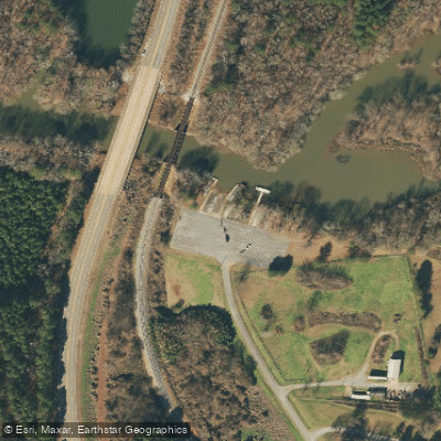
Boat Ramp
Flows, weather and a route-by-route verdict, so you know which stretch of the Talladega Creek is worth paddling today.
Live flows, marked hazards and fresh trip reports from paddlers who were just on the water, all in one place.





Every user gets free access to launch points, boat ramps, and public property parcels.
Loading popular cities...
PaddleWays gives you everything you need to plan smarter, paddle better, and own every trip from first launch to takeout.





