Turmeil Beach
- Saltwater
- Beach
Turmeil Beach
- Saltwater
- Beach
- Sq. miles
- 0.2
- Boat Ramps
- 0
- Access Points
- 0
- Campsites
- 2
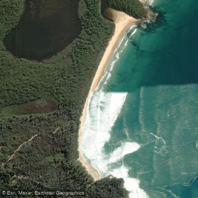
Turmeil Beach is a 1.7-kilometer stretch of unspoiled coastline within Meroo National Park on the New South Wales South Coast. The beach runs between Termeil Point and Meroo Head, which features a spectacular cove and rock formations suitable for exploration. Access for paddlers launching from shore is via Meroo Point Road off the Princes Highway, approximately 20 kilometers south of Ulladulla. The final access road to the Termeil Beach picnic area and carpark is unsealed and suitable for 2WD vehicles only in dry conditions, as it can become boggy after rain. Parking is available at the carpark, a short walk from the picnic area. No drinking water is available, so paddlers must bring their own. The beach's northern end is the entrance to Termeil Lake, a refuge for wildlife where swimming and kayaking are suitable and powerboats cannot access; however, the lake entrance is usually closed, and the lake itself is only reachable by foot. The beach provides scenic beachside camping areas at both ends. The overall character is one of seclusion within a national park setting. Paddling in the park's coastal lakes, such as Termeil Lake, is highlighted as an autumn activity. The beach is exposed to the Tasman Sea, and paddlers should be prepared for typical ocean conditions, including surf and wind. Summer air temperatures average between 9°C and 27°C, while winter averages range from 0°C to 13°C. Pets are prohibited in the national park.
Water access, boat ramps & amenities
Learn how to get on Turmeil Beach. Uncover great paddling access points, boat ramps, and all the facilities you need for an unforgettable day on the water. Some locations shown may border or include private property. Always check property boundaries and applicable regulations before visiting. PaddleWays's Public & Private Land layer can help you plan your access with confidence.
Paddle smarter with real-time insights
Whether you're en route and conditions shift or you're looking for the best spot based on current flows, we enable you to make informed decisions on the fly.








Find Places to Paddle

Over 400,000 Places to Paddle
Every user gets free access to launch points, boat ramps, and public property parcels.


Tides, wind & water conditions (10 day forecast)
On open water, wind and tide matter as much as the weather. See the best times to paddle Turmeil Beach and check the marine forecast before you launch.
Loading tide predictions…
Paddling near Turmeil Beach

Murrumbidgee River

Molonglo River

Queanbeyan River

Cotter River

Googong Reservoir

Shoalhaven River

Lake Burrinjuck

Goobagandra River

Eucumbene River

Lake Eucumbene
Explore New South Wales waters
Top paddling waters
No waters available right now.
Popular Cities
Loading popular cities...
Explore near Turmeil Beach

Smarter Paddling Starts in the App.
Paddleways gives you everything you need to plan smarter, paddle better, and own every trip from first launch to takeout.