Tuross Lake
- Saltwater
- Estuary
Tuross Lake
- Saltwater
- Estuary
- Sq. miles
- 13
- Boat Ramps
- 0
- Access Points
- 0
- Campsites
- 0
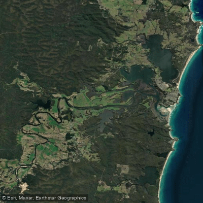
Tuross Lake is a coastal saltwater estuary located on the south coast of New South Wales, near the village of Tuross Head. It is a broad, sheltered body of water connected to the Tasman Sea via a dynamic inlet, with the Tuross River feeding into its upper reaches. The lake is characterized by a network of natural channels, islands, and shallow intertidal flats, offering a predominantly flatwater paddling environment. The long sandbar protecting the lake's entrance creates a wide beach that forms part of the Eurobodalla National Park. Primary access for paddlers is from the boat ramp and adjacent shallow sandy edge off Trafalgar Road/Nelson Parade at Lavender Bay, where there is ample free parking. This launch point provides easy entry into the lake. A notable secondary feature is a small waterfront café area on the lake where paddlers can tie their kayak directly to the dock. Toilets are also available near the main access area.
Paddling routes often involve exploring the lake's islands, such as Horse Island and Cambanthin Island, and connecting to the lower Tuross River. A popular day trip involves paddling southwest across the lake, around the south side of Horse Island, under a small bridge, and then left at a T-junction to reach the entrance to Borang Lake on the Tuross River. It is critical to note that the entrance to Borang Lake is shallow, and this section of the paddle is best undertaken on a high tide. Tidal influence is significant throughout the estuary, and paddlers should plan trips with tide charts, aiming to navigate shallow areas and channel junctions during higher water. The lake's entrance bar is known to be hazardous for powered boats, with shallow shoals creating breaking waves, indicating that paddlers should exercise extreme caution and likely avoid the immediate surf zone near the ocean inlet. The lake experiences wind exposure, and paddlers are advised to carry a map and compass due to the network of channels and islands which can make navigation confusing. Motorized boat traffic is present, including water skiing in the broadwater areas, so paddlers must remain aware. The water is generally clean and supports a diverse ecosystem; wildlife includes rays, fish, and various bird species. The overall experience is one of exploring a historic, working waterway with a mix of natural bushland, islands, and calm waters suitable for kayaks, canoes, and stand-up paddleboards.
Water access, boat ramps & amenities
Learn how to get on Tuross Lake. Uncover great paddling access points, boat ramps, and all the facilities you need for an unforgettable day on the water. Some locations shown may border or include private property. Always check property boundaries and applicable regulations before visiting. PaddleWays's Public & Private Land layer can help you plan your access with confidence.
Paddle smarter with real-time insights
Whether you're en route and conditions shift or you're looking for the best spot based on current flows, we enable you to make informed decisions on the fly.








Find Places to Paddle

Over 400,000 Places to Paddle
Every user gets free access to launch points, boat ramps, and public property parcels.


Tides, wind & water conditions (10 day forecast)
On open water, wind and tide matter as much as the weather. See the best times to paddle Tuross Lake and check the marine forecast before you launch.
Loading tide predictions…
Paddling near Tuross Lake

Murrumbidgee River

Molonglo River

Queanbeyan River

Cotter River

Googong Reservoir

Shoalhaven River

Lake Burrinjuck

Goobagandra River

Eucumbene River

Lake Eucumbene
Explore New South Wales waters
Top paddling waters
No waters available right now.
Popular Cities
Loading popular cities...
Explore near Tuross Lake

Smarter Paddling Starts in the App.
Paddleways gives you everything you need to plan smarter, paddle better, and own every trip from first launch to takeout.