Tamboon Inlet
- Saltwater
- Estuary
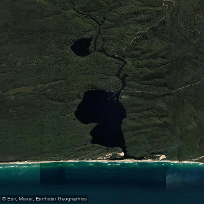
Tamboon Inlet
- Saltwater
- Estuary
- Sq. miles
- 3.7
- Boat Ramps
- 0
- Access Points
- 0
- Campsites
- 0
Tamboon Inlet is a coastal estuary located at the mouth of the Cann River, approximately one hour's drive south of Mallacoota within the Croajingolong National Park in far East Gippsland. It is a relatively isolated water body surrounded by dense forest and is part of a UNESCO World Biosphere Reserve. The inlet is accessible for paddlers via a formal boat launching ramp, which is one of several along this section of coast. A key access point for paddlers is the Peachtree Creek Campground, which is nestled on the inlet's shores and provides a potential launch site, and boat-access camping is available on the inlet's eastern shores. The overall character is one of coastal wilderness, featuring white-sand beaches, turquoise waters, and significant sand dunes.
The paddling experience here is defined by its remote, natural setting. The area is known for abundant birdlife, with Croajingolong National Park being home to half of Victoria's total bird species. Notable sights from the water include views towards the historic Point Hicks Lighthouse and the dramatic coastal scenery accessible via walking tracks like the Clinton Rocks Walk. The inlet connects to the winding waterways of the Cann River, offering extended exploration opportunities. Given its coastal and tidal nature, paddlers must plan for tidal currents and wind exposure across the open water. The region is busiest during the Australian summer, from December to February, which is considered the ideal time to visit, with February and March also being favorable.
Water access, boat ramps & amenities
Learn how to get on Tamboon Inlet. Uncover great paddling access points, boat ramps, and all the facilities you need for an unforgettable day on the water. Some locations shown may border or include private property. Always check property boundaries and applicable regulations before visiting. PaddleWays's Public & Private Land layer can help you plan your access with confidence.
Paddle smarter with real-time insights
Whether you're en route and conditions shift or you're looking for the best spot based on current flows, we enable you to make informed decisions on the fly.








Find Places to Paddle

Over 400,000 Places to Paddle
Every user gets free access to launch points, boat ramps, and public property parcels.


Tides, wind & water conditions (10 day forecast)
On open water, wind and tide matter as much as the weather. See the best times to paddle Tamboon Inlet and check the marine forecast before you launch.
Loading tide predictions…
Paddling near Tamboon Inlet

Murrumbidgee River

Molonglo River

Queanbeyan River

Cotter River

Googong Reservoir

Shoalhaven River

Lake Burrinjuck

Goobagandra River

Eucumbene River

Lake Eucumbene
Explore Victoria waters
Top paddling waters
No waters available right now.
Popular Cities
Loading popular cities...
Explore near Tamboon Inlet

Smarter Paddling Starts in the App.
Paddleways gives you everything you need to plan smarter, paddle better, and own every trip from first launch to takeout.