Howden Reservoir
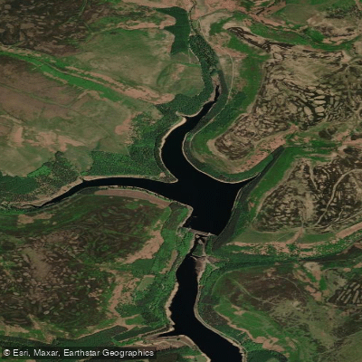
Howden Reservoir
- Boat Ramps
- 0
- Access Points
- 0
- Campsites
- 0
Howden Reservoir is the uppermost of three reservoirs in the Upper Derwent Valley, straddling the border between Derbyshire and South Yorkshire in the Peak District. It has a distinctive Y-shaped form, with the county boundary running through the middle of the reservoir along the original course of the River Derwent. The longest arm extends approximately 1¼ miles (2.0 km), making it a relatively compact water body. The reservoir is bounded at its southern end by Howden Dam, below which the River Derwent flows directly into Derwent Reservoir and then Ladybower Reservoir. Primary inflows include the River Derwent, River Westend, Howden Clough, and Linch Clough.
Kayaking is among the recreational activities associated with the Derwent Valley reservoirs, which collectively attract around 2 million visitors per year. Road access runs along the western shoreline, with parking available at the end of the road near postcode S33 0BB. Paddlers should be aware that this road is closed on weekends and bank holidays, which significantly affects vehicle access to the northern end of the reservoir. A 16.4 km footpath loops around both Howden and Derwent Reservoirs for those combining paddling with walking. The Upper Derwent Visitor Centre, located near Derwent Dam to the south, provides toilets and a café and may serve as a useful reference point when planning a visit to the area. The reservoir is surrounded by gritstone moorland and conifer woodland, characteristic of the Upper Derwent Valley landscape.
Water access, boat ramps & amenities
Learn how to get on Howden Reservoir. Uncover great paddling access points, boat ramps, and all the facilities you need for an unforgettable day on the water. Some locations shown may border or include private property. Always check property boundaries and applicable regulations before visiting. PaddleWays's Public & Private Land layer can help you plan your access with confidence.
Paddle smarter with real-time insights
Whether you're en route and conditions shift or you're looking for the best spot based on current flows, we enable you to make informed decisions on the fly.








Find Places to Paddle

Over 400,000 Places to Paddle
Every user gets free access to launch points, boat ramps, and public property parcels.


Water and weather conditions (10 day forecast)
See the best times to paddle Howden Reservoir and check the forecast before you go.
No forecast data available.
Paddling near Howden Reservoir
River Don
River Rother

HUMBER UPPER
River Derwent

River Dearne

HUMBER MIDDLE
River Wye
River Ashop

MERSEY
River Idle
Explore England waters
Top paddling waters
No waters available right now.
Popular Cities
Loading popular cities...
Explore near Howden Reservoir

Smarter Paddling Starts in the App.
Paddleways gives you everything you need to plan smarter, paddle better, and own every trip from first launch to takeout.