Ladybower Reservoir
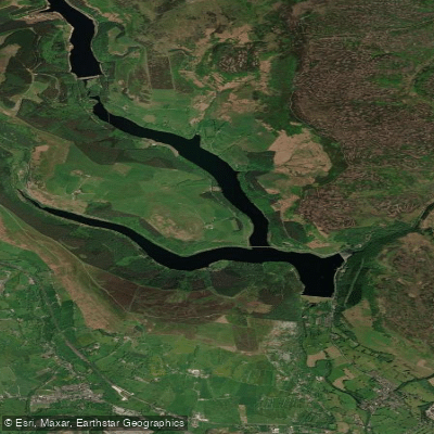
Ladybower Reservoir
- Boat Ramps
- 0
- Access Points
- 0
- Campsites
- 0
Ladybower Reservoir is a large body of water situated in the heart of the Peak District National Park in Derbyshire, surrounded by Dark Peak moorland and gritstone edges. The reservoir was constructed between 1935 and 1943 to supply water to the towns and cities surrounding the Peak District. It is owned and managed by Severn Trent Water. The reservoir has a distinctive Y-shaped layout: the southern dam sits just above the village of Bamford, with the main body extending westward along the Snake road for a couple of miles to meet the River Ashop, which flows down from the north of Kinder Scout. A second arm passes under the Ashopton road bridge and stretches north to Fairholmes, where it meets the Derwent Reservoir. The reservoir also features two prominent shaft spillways — commonly known as "plug holes" — each with a diameter of 24 metres, which activate when water levels are high. These are a notable visual feature but represent a serious hazard; Severn Trent has explicitly warned that anyone entering them would be seriously injured and would require a professional rescue team to extract them.
Historically, paddlesports were banned on Ladybower, with access restricted to anglers. Following years of negotiations with Severn Trent, paddling was opened up through a managed access arrangement operated by Ladybower Paddlesports, based at the Fisheries. Under that arrangement, paddlers were required to book in at the fisheries office and pay a launch fee of £10 per person, with access available on selected days (Wednesdays, Fridays, and Saturdays, 09:00–16:00). However, the paddlesports provider has since ceased operations, and Severn Trent is actively seeking a new qualified operator to resume activities. Paddlers should check directly with Severn Trent or the Ladybower Paddlesports website before planning a visit, as access arrangements are subject to change and the situation remains in flux.
The paddling environment offers views of Bamford Edge and Derwent Edge, with routes extending up the Ashop arm and northward under the Ashopton bridge toward Fairholmes. One recorded paddle covered 3.3 miles without reaching the full extent of the reservoir. The surrounding landscape of gritstone edges and moorland provides a visually distinctive backdrop throughout.
Water access, boat ramps & amenities
Learn how to get on Ladybower Reservoir. Uncover great paddling access points, boat ramps, and all the facilities you need for an unforgettable day on the water. Some locations shown may border or include private property. Always check property boundaries and applicable regulations before visiting. PaddleWays's Public & Private Land layer can help you plan your access with confidence.
Paddle smarter with real-time insights
Whether you're en route and conditions shift or you're looking for the best spot based on current flows, we enable you to make informed decisions on the fly.








Find Places to Paddle

Over 400,000 Places to Paddle
Every user gets free access to launch points, boat ramps, and public property parcels.


Water and weather conditions (10 day forecast)
See the best times to paddle Ladybower Reservoir and check the forecast before you go.
Yorkshire Bridge
Paddling near Ladybower Reservoir
River Don
River Rother

HUMBER UPPER
River Derwent

River Dearne

HUMBER MIDDLE
River Wye
River Ashop

MERSEY
River Idle
Explore England waters
Top paddling waters
No waters available right now.
Popular Cities
Loading popular cities...
Explore near Ladybower Reservoir

Smarter Paddling Starts in the App.
Paddleways gives you everything you need to plan smarter, paddle better, and own every trip from first launch to takeout.