Coyote Lake
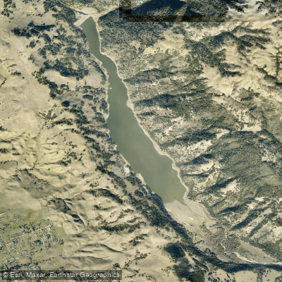
Coyote Lake
- Boat Ramps
- 1
- Access Points
- 2
- Campsites
- 13
Coyote Lake is a 635-acre artificial reservoir located in Santa Clara County between Morgan Hill and Gilroy. The lake stretches 3.5 miles in length with a maximum width of 0.5 miles, impounded by Coyote Dam built in 1936. At an elevation of 774 feet, this reservoir is managed by the Santa Clara Valley Water District and surrounded by the 4,595-acre Coyote Lake Harvey Bear Ranch County Park.
Paddling is permitted on Coyote Lake with both power and limited power boating allowed. The lake accommodates kayaks, canoes, paddleboards, and other non-motorized watercraft. A boat launch ramp is located two miles north of the visitor center, featuring two docks, a three-lane concrete ramp, paved parking, and restroom facilities. The launch area provides convenient access for launching paddlecraft.
The paddling season runs from mid-April through mid-October, with the lake closed to all boating between mid-October and mid-April. County park boating hours begin at 8:00 AM, and all vessels must be off the water thirty minutes before sunset. Personal flotation devices must be available for each person on board, and children under 13 must wear Coast Guard approved life jackets at all times.
Several regulations apply to paddlers. A County of Santa Clara vessel registration declaration form must be completed annually before entering park waters. DMV vessel registration and quagga mussel stickers must be current and attached to vessels. California Boater Cards are required when operating any vessel on county waterways. Swimming is prohibited in the reservoir by order of the Santa Clara Valley Water District.
The lake contains various fish species including bluegill, black crappie, channel catfish, carp, and black bass, making it popular among kayak anglers. However, the California Office of Environmental Health Hazard Assessment has issued a safe eating advisory for fish caught in Coyote Lake due to elevated mercury levels.
Entrance and vessel inspection fees are required for launch. The surrounding county park offers camping, picnicking, and hiking opportunities that complement paddling visits.
Water access, boat ramps & amenities
Learn how to get on Coyote Lake. Uncover great paddling access points, boat ramps, and all the facilities you need for an unforgettable day on the water. Some locations shown may border or include private property. Always check property boundaries and applicable regulations before visiting. PaddleWays's Public & Private Land layer can help you plan your access with confidence.
Paddle smarter with real-time insights
Whether you're en route and conditions shift or you're looking for the best spot based on current flows, we enable you to make informed decisions on the fly.








Find Places to Paddle

Over 400,000 Places to Paddle
Every user gets free access to launch points, boat ramps, and public property parcels.


Water and weather conditions (10 day forecast)
See the best times to paddle Coyote Lake and check the forecast before you go.
No forecast data available.
Paddling near Coyote Lake

San Joaquin River

Merced River
Monterey Bay

Tuolumne River

Stanislaus River
Soquel Cove
Anderson Lake

San Francisco Bay
Uvas Reservoir
Explore California waters
Top paddling waters
Popular Cities
Loading popular cities...
Explore near Coyote Lake
Access points
Nearby waters
More in California

Smarter Paddling Starts in the App.
Paddleways gives you everything you need to plan smarter, paddle better, and own every trip from first launch to takeout.