Torside Reservoir
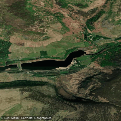
Torside Reservoir
- Boat Ramps
- 0
- Access Points
- 0
- Campsites
- 0
Torside Reservoir is the largest of the Longdendale Chain of reservoirs in north Derbyshire, England, situated at an elevation of approximately 199 metres above sea level. It covers a surface area of around 65 hectares (160 acres) with a maximum length of 2.25 kilometres, giving paddlers a meaningful stretch of open water to work with. The average depth is recorded at approximately 26 metres, making it considerably deeper than its classification as "shallow" in some datasets might suggest. The reservoir is fed primarily by the River Etherow, Crowden Brook, and Torside Clough, and discharges back into the River Etherow.
The water is characterised as low alkalinity and humic in nature, typical of upland Pennine catchments. The fetch distance of just over 2 kilometres means that wind-driven waves can develop across the open water, a consideration for paddlers in exposed conditions. The surrounding landscape consists of moorland hills on either side of the valley, with stands of conifers and larch woodland along sections of the shoreline.
Wildlife in the area includes deer, hares, and herons, and the reedy wetlands around the head of the reservoir provide additional habitat interest. The Longdendale Trail, a multi-use path built on a former railway line, runs along the southern edge of the reservoir and is used by walkers, cyclists, and horse riders, providing context for the broader recreational character of the valley.
Parking is available off the B6105, and toilet facilities are located at the Upper Longdendale Valley Memorial Forest car park. A campsite at Crowden lies nearby, offering an option for those planning overnight trips in the area. The A628, a busy main road, runs close to the dam end of the reservoir.
Paddling permissions, access points for launching, and any paddling-specific regulations are not clearly established for this reservoir. Prospective paddlers should verify current access rights and any restrictions with the relevant water authority before planning a trip, as the reservoir is part of a managed water supply system.
Water access, boat ramps & amenities
Learn how to get on Torside Reservoir. Uncover great paddling access points, boat ramps, and all the facilities you need for an unforgettable day on the water. Some locations shown may border or include private property. Always check property boundaries and applicable regulations before visiting. PaddleWays's Public & Private Land layer can help you plan your access with confidence.
Paddle smarter with real-time insights
Whether you're en route and conditions shift or you're looking for the best spot based on current flows, we enable you to make informed decisions on the fly.








Find Places to Paddle

Over 400,000 Places to Paddle
Every user gets free access to launch points, boat ramps, and public property parcels.


Water and weather conditions (10 day forecast)
See the best times to paddle Torside Reservoir and check the forecast before you go.
Torside
Paddling near Torside Reservoir
River Mersey
River Douglas

MERSEY
River Colne
River Don
RIBBLE
River Weaver
River Wye
Mersey Mouth
River Ashop
Explore England waters
Top paddling waters
No waters available right now.
Popular Cities
Loading popular cities...
Explore near Torside Reservoir

Smarter Paddling Starts in the App.
Paddleways gives you everything you need to plan smarter, paddle better, and own every trip from first launch to takeout.