Belmont Bay
- Saltwater
- Bay
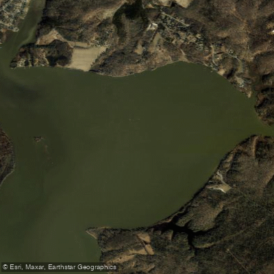
Belmont Bay
- Saltwater
- Bay
- Sq. miles
- 1.6
- Boat Ramps
- 0
- Access Points
- 0
- Campsites
- 1
Belmont Bay is a shallow, tidal saltwater bay on the Potomac River in Northern Virginia, providing a protected paddling environment with significant wildlife viewing. The primary public access for car-top boats is the dedicated launch at Mason Neck State Park, located off High Point Road in Lorton. This launch provides direct entry to the bay and is the starting point for guided tours. A private launch for residents is maintained by the Belmont Bay Paddlers Club on the Occoquan River in Woodbridge, but membership is restricted to local homeowners. The bay is fairly shallow, which generally limits large boat traffic, though jet skis and other small craft may be present. As a tidal feature of the Potomac River, paddlers must plan for tidal currents. Kane's Creek, a pristine tidal marsh that flows into the bay's northern end, is a popular destination; paddling upstream is possible for about a mile from its mouth, but access is prohibited beyond signs marking a protected bald eagle nesting area. Water levels in the creek are tide-dependent, and during low tide, navigable distance may be reduced to about three-quarters of a mile. The area is renowned for abundant wildlife, including bald eagles, osprey, great blue herons, egrets, beaver, turtles, and deer. Early morning and evening are particularly good times for wildlife observation and calm conditions. The park charges a daily entrance fee, and guided paddle adventures are offered for an additional cost. The overall experience is characterized by a quiet, natural escape close to the urban area, with opportunities for peaceful exploration and reliable eagle sightings.
Water access, boat ramps & amenities
Learn how to get on Belmont Bay. Uncover great paddling access points, boat ramps, and all the facilities you need for an unforgettable day on the water. Some locations shown may border or include private property. Always check property boundaries and applicable regulations before visiting. PaddleWays's Public & Private Land layer can help you plan your access with confidence.
Paddle smarter with real-time insights
Whether you're en route and conditions shift or you're looking for the best spot based on current flows, we enable you to make informed decisions on the fly.








Find Places to Paddle

Over 400,000 Places to Paddle
Every user gets free access to launch points, boat ramps, and public property parcels.


Tides, wind & water conditions (10 day forecast)
On open water, wind and tide matter as much as the weather. See the best times to paddle Belmont Bay and check the marine forecast before you launch.
Loading tide predictions…
Paddling near Belmont Bay

Potomac River
Triadelphia Reservoir
Georgetown Channel

Patuxent River
Piscataway Creek
Monocacy River
Patapsco River
Gunston Cove

Rappahannock River
Explore Virginia waters
Top paddling waters
Popular Cities
Loading popular cities...
Explore near Belmont Bay

Smarter Paddling Starts in the App.
Paddleways gives you everything you need to plan smarter, paddle better, and own every trip from first launch to takeout.