Turner Pond
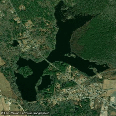
Turner Pond
- Boat Ramps
- 1
- Access Points
- 2
- Campsites
- 0
Turner Pond is a 55-acre impoundment of the Pasakamansett River located in North Dartmouth, Bristol County, Massachusetts. This warmwater pond lies just northwest of the New Bedford Municipal Airport, with the majority of its acreage falling within the Acushnet Cedar Swamp State Reservation.
**Character and Water Quality:** The pond is characterized by dark brown, highly acidic water (pH 4.2 to 4.9) resulting from drainage from the Acushnet Cedar Swamp. Water transparency is poor at approximately 1.5 feet, and the pond features a mud bottom throughout. The average depth is four feet, with a maximum depth of 20 feet. Emergent aquatic vegetation covers nearly half the surface area during summer months, which can impact navigation.
**Access:** Turner Pond offers excellent accessibility for shore fishing and launching cartop boats and canoes. Old Fall River Road runs along the dam end of the pond, while High Hill Road cuts through the middle, providing multiple access points. Parking is available on adjacent conservation land and along roadsides. The 2.3-mile undeveloped shoreline provides a natural setting for paddlers.
**Historical Context:** An 1912 survey reported the pond was historically known as Turner's Mill Pond and the Pond at North Village. It would dry in summer except for the river channel, though modern management has maintained more consistent water levels.
**Wildlife and Fishing:** Fish populations are notably sparse due to the acidic conditions. Species present include yellow perch (dominant), banded sunfish, golden shiner, black crappie, brown bullhead, chain pickerel, American eel, and tesselated darter. Anglers have reported some largemouth bass. The acidic environment limits fish populations, with surveys indicating poor body condition for most species. During summer, low oxygen levels in deeper areas confine fish to the top 8 feet of water or shallower. While the scenery offers a peaceful natural setting within the state reservation, paddlers should be aware that fishing opportunities are limited and conditions may continue to deteriorate as species struggle with the acidic water chemistry.
Water access, boat ramps & amenities
Learn how to get on Turner Pond. Uncover great paddling access points, boat ramps, and all the facilities you need for an unforgettable day on the water. Some locations shown may border or include private property. Always check property boundaries and applicable regulations before visiting. PaddleWays's Public & Private Land layer can help you plan your access with confidence.
Paddle smarter with real-time insights
Whether you're en route and conditions shift or you're looking for the best spot based on current flows, we enable you to make informed decisions on the fly.








Find Places to Paddle

Over 400,000 Places to Paddle
Every user gets free access to launch points, boat ramps, and public property parcels.


Water and weather conditions (10 day forecast)
See the best times to paddle Turner Pond and check the forecast before you go.
No forecast data available.
Paddling near Turner Pond

Taunton River
Pawcatuck River
Buzzards Bay

Charles River

Sudbury River
Rhode Island Sound
Clear River
Narragansett Bay
South Watuppa Pond
Explore Massachusetts waters
Top paddling waters
Popular Cities
Loading popular cities...
Explore near Turner Pond
Access points
Nearby waters
More in Massachusetts

Smarter Paddling Starts in the App.
Paddleways gives you everything you need to plan smarter, paddle better, and own every trip from first launch to takeout.